geo.wikisort.org - Montagne
Les Gorgany (en ukrainien Ґорґа́ни) sont un massif montagneux d'Ukraine qui fait partie des Carpates orientales. Le massif culmine à 1 836 mètres d'altitude au mont Syvoulia. Il domine le col Yablonitsky et les sources du Prout.


Cet article est une ébauche concernant la montagne et l’Ukraine.
Vous pouvez partager vos connaissances en l’améliorant (comment ?) selon les recommandations des projets correspondants.
| Gorgany | |
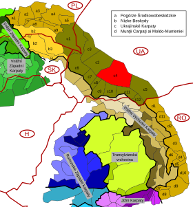 Carte de localisation des Gorgany (C4 en rouge) au sein des Carpates orientales extérieures (brun à jaune-ocre). | |
| Géographie | |
|---|---|
| Altitude | 1 836 m, Mont Syvoulia |
| Massif | Carpates |
| Administration | |
| Pays | |
| Oblasts | Ivano-Frankivsk, Transcarpatie |
| Géologie | |
| Roches | Flysch |
| modifier |
|
Notes et références
- (en) Cet article est partiellement ou en totalité issu de l’article de Wikipédia en anglais intitulé « Gorgany » (voir la liste des auteurs).
 Portail de la montagne
  Portail des Carpates
  Portail de l’Ukraine
На других языках
[de] Gorgany
Die Gorgany (ukrainisch Ґорґани; russisch Горганы) ist ein Gebirge in der Westukraine.[en] Gorgany
Gorgany (Ukrainian: Ґорґани) is a mountain range in Western Ukraine in Outer Eastern Carpathians, adjacent to Chornohora range. The highest peak of Gorgany is Syvulia (1,836 m) with the other high peaks including Ihrovyshche, Vysoka [uk] (1,804 m), Lopushna [uk] (1,772 m) and Grofa. The mountains are made of flysch rock, mostly sandstone, which create typical for Gorgany debris fields (local names: gorgan, grekhot). They are bordered by the Mizunka River and Vyshkovsky Pass in the west and the Prut River and Yablonitsky Pass in the east.- [fr] Gorgany
[ru] Горганы
Горганы (укр. Ґорґани) — система горных хребтов во внешней полосе Украинских Карпат, расположенных в Ивано-Франковской и Закарпатской областях. Простираются на 75 км с северо-запада от долины Мизунки и Рики на юго-восток до долины Прута. Ширина с запада на восток составляет около 40 км.Текст в блоке "Читать" взят с сайта "Википедия" и доступен по лицензии Creative Commons Attribution-ShareAlike; в отдельных случаях могут действовать дополнительные условия.
Другой контент может иметь иную лицензию. Перед использованием материалов сайта WikiSort.org внимательно изучите правила лицензирования конкретных элементов наполнения сайта.
Другой контент может иметь иную лицензию. Перед использованием материалов сайта WikiSort.org внимательно изучите правила лицензирования конкретных элементов наполнения сайта.
2019-2026
WikiSort.org - проект по пересортировке и дополнению контента Википедии
WikiSort.org - проект по пересортировке и дополнению контента Википедии