geo.wikisort.org - Montagne
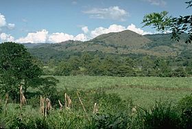
Le Cuilapa-Barbarena est un champ volcanique du Guatemala.
| Cuilapa-Barbarena | |
 Vue d'une partie du Cuilapa-Barbarena. | |
| Géographie | |
|---|---|
| Altitude | 1 454 m |
| Massif | Sierra Madre de Chiapas |
| Coordonnées | 14° 19′ 55″ nord, 90° 22′ 23″ ouest |
| Administration | |
| Pays | |
| Département | Santa Rosa |
| Géologie | |
| Type | Volcan de subduction |
| Activité | Inconnue |
| Dernière éruption | Inconnue |
| Code GVP | 342111 |
| modifier |
|
Voir aussi
Articles connexes
Liens externes
- (en) Cuilapa-Barbarena (Global Volcanism Program)
- Portail du Guatemala
- Portail de la montagne
- Portail du volcanisme
На других языках
[en] Cuilapa-Barbarena
The Cuilapa-Barbarena volcanic field is a field of cinder cones in Guatemala with approximately 70 cones. The field is located over the intersection of the local Jalpatagua fault with the Miocene Santa Rosa de Lima caldera. The youngest cones postdate the last activity phase of Tecuamburro and may be of Holocene age,[1] but with no confirmed evidence.[2]- [fr] Cuilapa-Barbarena
Текст в блоке "Читать" взят с сайта "Википедия" и доступен по лицензии Creative Commons Attribution-ShareAlike; в отдельных случаях могут действовать дополнительные условия.
Другой контент может иметь иную лицензию. Перед использованием материалов сайта WikiSort.org внимательно изучите правила лицензирования конкретных элементов наполнения сайта.
Другой контент может иметь иную лицензию. Перед использованием материалов сайта WikiSort.org внимательно изучите правила лицензирования конкретных элементов наполнения сайта.
2019-2025
WikiSort.org - проект по пересортировке и дополнению контента Википедии
WikiSort.org - проект по пересортировке и дополнению контента Википедии
