geo.wikisort.org - Montagne
Capulin Volcano National Monument est situé dans le Nord-Est du Nouveau-Mexique, aux États-Unis. Il a été classé monument national américain le .
| Capulin | |||
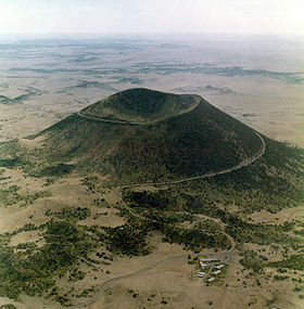
 Vue aérienne du Capulin. | |||
| Géographie | |||
|---|---|---|---|
| Altitude | 2 494 m[1] | ||
| Massif | Johnson Mesa | ||
| Coordonnées | 36° 47′ 02″ nord, 103° 58′ 05″ ouest[1] | ||
| Administration | |||
| Pays | |||
| État | Nouveau-Mexique | ||
| Comté | Union | ||
| Géologie | |||
| Type | Volcan de rift | ||
| Activité | Éteint | ||
| Dernière éruption | 56 000 à 62 000 ans | ||
| Code GVP | 327820 | ||
| Observatoire | Aucun | ||
| Géolocalisation sur la carte : États-Unis
Géolocalisation sur la carte : Nouveau-Mexique
| |||
| modifier |
|||
Monument national de Capulin Volcano
| Pays | |
|---|---|
| État | |
| Superficie |
3,21 km2[2] |
| Type |
Monument national, unité du National Park System |
|---|---|
| Catégorie UICN |
V |
| WDPA | |
| Création | |
| Patrimonialité | |
| Administration |
National Park Service |
| Site web |
[abbr class="abbr indicateur-langue" title="Langue : anglais">(en) Capulin Volcano National Monument] |
Géographie
Le volcan Capulin est un volcan rouge éteint dont la dernière éruption remonte à 60 000 ans. Il fait partie du champ volcanique de Raton-Clayton, qui compte une centaine de volcans. La profondeur du cratère est de 120 mètres environ.
Tourisme
Une route pavée s'enroule autour du volcan jusqu'à un parking au bord du cratère. Un sentier de randonnée circulaire d'environ 1,5 km fait le tour du cratère et descend au fond.
Notes et références
- Visualisation sur l'USGS.
- « National Park Service: Listing of Acreage as of 09/30/2009 », sur National Park Service, (consulté le ), p. 2
Voir aussi
Articles connexes
- Liste des monuments nationaux américains
Liens externes
- Ressources relatives à la géographie :
- Ressources relatives à l'architecture :
- (en) Harpers Ferry Center
- (en) National Park Foundation
- (en) NPS Stats
- (en) Capulin Volcano National Monument sur Natural Atlas
- (en) Site officiel
- Portail de la montagne
- Portail du volcanisme
- Portail de la conservation de la nature
- Portail du Nouveau-Mexique
На других языках
[en] Capulin Volcano National Monument
Capulin Volcano National Monument is a U.S. National Monument located in northeastern New Mexico that protects and interprets an extinct cinder cone volcano and is part of the Raton-Clayton volcanic field. A paved road spirals gradually around the volcano and visitors can drive up to a parking lot at the rim of the extinct volcano. Hiking trails circle the rim as well as lead down into the mouth of the volcano. The monument was designated on August 9, 1916, and is administered by the National Park Service. The volcano is located 5 kilometres (3.1 mi) north of the village of Capulin.- [fr] Capulin Volcano National Monument
[ru] Капилен
Капилен (англ. Capulin) — потухший вулкан. Площадь — 3,21 км².[источник не указан 473 дня]Текст в блоке "Читать" взят с сайта "Википедия" и доступен по лицензии Creative Commons Attribution-ShareAlike; в отдельных случаях могут действовать дополнительные условия.
Другой контент может иметь иную лицензию. Перед использованием материалов сайта WikiSort.org внимательно изучите правила лицензирования конкретных элементов наполнения сайта.
Другой контент может иметь иную лицензию. Перед использованием материалов сайта WikiSort.org внимательно изучите правила лицензирования конкретных элементов наполнения сайта.
2019-2025
WikiSort.org - проект по пересортировке и дополнению контента Википедии
WikiSort.org - проект по пересортировке и дополнению контента Википедии


