geo.wikisort.org - Montagne
Le Breithorn est une montagne du massif des Alpes pennines, à la frontière entre la Suisse (canton du Valais) et l'Italie (Vallée d'Aoste).
Pour les articles homonymes, voir Breithorn (homonymie).
Cet article est une ébauche concernant la montagne, le canton du Valais et la Vallée d’Aoste.
Vous pouvez partager vos connaissances en l’améliorant (comment ?) selon les recommandations des projets correspondants.
| Breithorn | |||||
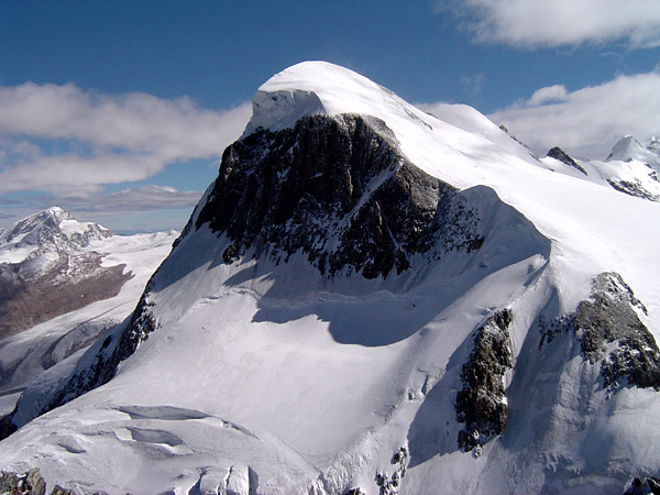 Vue du Breithorn depuis le Petit Cervin. | |||||
| Géographie | |||||
|---|---|---|---|---|---|
| Altitude | 4 163 ou 4 165 m, Breithorn occidental[1],[2] | ||||
| Massif | Alpes pennines (Alpes) | ||||
| Coordonnées | 45° 56′ 28″ nord, 7° 44′ 52″ est[1],[2] | ||||
| Administration | |||||
| Pays | |||||
| Canton Région à statut spécial |
Valais Vallée d'Aoste |
||||
| District | Viège | ||||
| Ascension | |||||
| Première | , par Henry Maynard avec Jean-Marie Couttet, Jean Gras, Jean-Baptiste et Jean-Jacques Érin | ||||
| Voie la plus facile | Par le Petit Cervin (3 820 m) | ||||
| Géolocalisation sur la carte : Vallée d'Aoste
Géolocalisation sur la carte : canton du Valais
Géolocalisation sur la carte : Italie
Géolocalisation sur la carte : Suisse
| |||||
| modifier |
|||||


Toponymie
Breithorn signifie littéralement Corne large en allemand.
Topographie

Le Breithorn possède cinq sommets principaux :
- le Breithorn occidental (4 163 ou 4 165 m) ;
- le Breithorn central (4 156 ou 4 160 m) ;
- le Breithorn oriental (4 138 ou 4 141 m) ;
- le Breithornzwillinge (4 106 m) ;
- la roche Noire[3] (4 074 ou 4 075 m).
Alpinisme
La première ascension du Breithorn a été réalisée le par Henry Maynard avec Jean-Marie Couttet[4],[5],[6], Jean Gras, Jean-Baptiste et Jean-Jacques Érin.
Actuellement le Breithorn est considéré comme le 4 000 le plus facile des Alpes car un téléphérique amène les alpinistes au Petit Cervin, à 3 820 m d'altitude.
Cependant, d'autres voies[Lesquelles ?] avec des dénivelés bien plus importants[précision nécessaire] sont aussi très prisées des alpinistes aguerris.
Notes et références
- Visualisation sur Swisstopo.
- Visualisation sur le géoportail italien.
- Roche Noire, www.lovevda.it - Office du tourisme de la région autonome Vallée d'Aoste.
- Jean Marie Couttet (1764-1848) est l'un des guides de Horace-Bénédict de Saussure et le père de Joseph-Marie Couttet (1793-1877)
- Gérard Bordes, Grande Encyclopédie de la Montagne, t. 3, Paris, Atlas, , 2400 p., page 745
- Sylvain Jouty et Hubert Odier, Dictionnaire de la montagne, Paris, Place des éditeurs, , 883 p. (ISBN 978-2-258-08220-5, présentation en ligne), article Breithorn
Articles connexes
- Classement des sommets des Alpes de plus de 4 000 mètres
 Portail de la montagne
  Portail des Alpes
  Portail de la Vallée d'Aoste
  Portail du Valais
  Portail de la géographie de la Suisse
На других языках
[de] Breithorn (Zermatt)
Das Breithorn ist ein fünfgipfliger, von West nach Ost verlaufender, stark vergletscherter Bergkamm in den Walliser Alpen. Der höchste Punkt des Kamms und zugleich bergsteigerisch leichteste Viertausender der Alpen ist der Westgipfel (Hauptgipfel, Breithorn Occidentale, 4164 m ü. M.). Weiter nach Osten folgen der Mittelgipfel (4159 m ü. M.) sowie die Breithorn-Zwillinge, bestehend aus dem Ostgipfel (westlicher Zwilling, 4139 m ü. M.) und dem Gendarm (östlicher Zwilling 4106 m ü. M.). Der Breithornkamm endet im Osten mit der Schwarzfluh (4075 m ü. M.).[en] Breithorn
The Breithorn (German for literally "broad horn"; 13,661 ft. or 4,164 m) is a mountain range of the Pennine Alps with its highest peak of the same name (but also called Breithorn (Western Summit)), located on the border between Switzerland and Italy. It lies on the main chain of the Alps, approximately halfway between the Matterhorn and Monte Rosa and east of the Theodul Pass. Most of the massif is glaciated and includes several subsidiary peaks, all located east of the main summit: the Central Breithorn, the western Breithorn Twin (or Eastern Breithorn), the Gendarm (or eastern Breithorn Twin) and the Roccia Nera. The main summit is sometimes distinguished by the name Western Breithorn (German: Breithorn (Westgipfel), Italian: Breithorn Occidentale). The nearest settlements are Zermatt (Valais) and St-Jacques (Aosta Valley).- [fr] Breithorn
[it] Monte Breithorn
Il monte Breithorn (4.165 m s.l.m.) è una montagna che fa parte della catena montuosa del Monte Rosa nelle Alpi Pennine.[ru] Брайтхорн (Пеннинские Альпы)
Брайтхо́рн (нем. Breithorn) — гора в Пеннинских Альпах, на границе Швейцарии и Италии, недалеко от Маттерхорна. Её высота — 4164 метров над уровнем моря.Другой контент может иметь иную лицензию. Перед использованием материалов сайта WikiSort.org внимательно изучите правила лицензирования конкретных элементов наполнения сайта.
WikiSort.org - проект по пересортировке и дополнению контента Википедии