geo.wikisort.org - Montañas
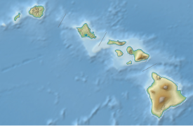
Lōʻihi es un volcán submarino activo, que se encuentra a unos 35 km al sureste de la costa de la isla de Hawái.[1] Se encuentra sobre un lateral de Mauna Loa, el mayor volcán en escudo de la Tierra. Lōʻihi es el volcán más joven de la cadena de volcanes Hawái-Emperador, una sucesión de volcanes que se extiende por más de 5800 km al noroeste de Lōʻihi y la isla de Hawái. A diferencia de la mayoría de los volcanes activos del océano Pacífico que se localizan en los bordes de placas activos del Cinturón de Fuego del Pacífico, Lōʻihi y los otros volcanes de la cadena submarina Hawái-Emperador son volcanes de punto caliente y se formaron a grandes distancias de los límites de la placa más próxima. Los volcanes de las islas de Hawái se originan en el punto caliente de Hawái, y Lōʻihi como el volcán más joven de la cadena es el único volcán de Hawái en la etapa de desarrollo submarino profundo denominada "pre-escudo". Lōʻihi comenzó a formarse hace unos 400 000 años y se estima que emergerá de la superficie del mar dentro de unos 10 000 a 100 000 años. La cima del Lōʻihi se eleva unos 3000 m sobre el suelo marino, por lo que es más elevado que lo que el Monte Santa Helena era antes de su erupción en 1980. En las inmediaciones de las numerosas fuentes hidrotermales de Lōʻihi se desarrolla una comunidad de microbios sumamente variada.
| Lō'ihi | ||
|---|---|---|
 Lō'ihi en 3D | ||
| Localización geográfica | ||
| Región | Isla de Hawái | |
| Cordillera | Cadena de montes submarinos Hawái-Emperador | |
| Sierra | Cadena de volcanes Hawái-Emperador | |
| Coordenadas | 18°55′N 155°16′O | |
| Localización administrativa | ||
| País | Estados Unidos | |
| División | Condado de Hawái | |
| Localización | Hawái, EE. UU. | |
| Características generales | ||
| Tipo | volcán de punto caliente | |
| Altitud | -3000 msnm | |
| Geología | ||
| Era geológica | 400,000 | |
| Observatorio | Observatorio Vulcanológico de Hawái | |
| Mapa de localización | ||
 Lō'ihi Ubicación del Lō'ihi en Hawái | ||
Véase también
- Punto caliente de Hawái
- Cadena de montes submarinos Hawái-Emperador
- Volcanes de la cadena Hawái-Emperador
Referencias
- Malahoff, Alexander (18 de diciembre de 2000). «Lōʻihi Submarine Volcano: A unique, natural extremophile laboratory». In the Spotlight. Office of Oceanic and Atmospheric Research (NOAA). Archivado desde el original el 16 de febrero de 2009. Consultado el 1 de marzo de 2009.
Bibliografía
- Auerbach-Caplan, J.; F. Duennebier (25 de mayo de 2001). «Seismic and acoustic signals detected at Loʻihi Seamount by the Hawaiʻi Undersea Geo-Observatory». Geochemistry Geophysics Geosystems (American Geophysical Union and the Geochemical Society) 2 (5): 1525-2027. ISSN 1525-2027. doi:10.1029/2000GC000113. Consultado el 27 de abril de 2009.
- Chave, E. H.; Alexander Malahoff (1998). In Deeper Waters: Photographic Studies of Hawaiian Deep-sea Habitats and Life-forms. University of Hawaiʻi Press. ISBN 0824820037.
- Duennebier, F. K.; N. C. Becker, J. Caplan-Auerbach, D. A. Clague, J. Cowen, M. Cremer, M. Garcia, F. Goff, A. Malahoff, G. M. McMurtry, B. P. Midson, C. L. Moyer, M. Norman, P. Okubo, J. A. Resing, J. M. Rhodes, K. Rubin, F. J. Sansone, J. R. Smith, K. Spencer, X. Wen, and C. G. Wheat (3 de junio de 1997). «Researchers rapidly respond to submarine activity at Lōʻihi volcano, Hawaiʻi». EOS Trans. Am. Geophys. Union 78 (22): 229-33. doi:10.1029/97EO00150.
- Emery, K.O. (1955). «Submarine topography south of Hawaiʻi». Pacific Science (University of Hawaiʻi Press) 9: 286-91.
- «Loihi - Data Sources». Global Volcanism Program. Smithsonian Institution.
- Klein, F. (1982). «Earthquakes at Lōʻihi submarine volcano and the Hawaiian hot spot». Journal of Geophysical Research 87: B9. ISSN 0148-0227.
- Macdonald, G.A. (1952). "The South Hawaiʻi Earthquakes of March and April, 1952." The Volcano Letter. U.S. Geological Survey Professional Paper 515.
- Malahoff, Alexander; Gary M. McMurtry; John C. Wiltshire; Hsueh-Wen Yeh (15 de julio de 1982). «Geology and chemistry of hydrothermal deposits from active submarine volcano Lōʻihi, Hawaiʻi». Nature (Nature Publishing Group) 298 (5871): 234-39. doi:10.1038/298234a0.
- Malahoff, A.; Gregory, T. Bossuyt, A. Donachie, S. Alarn, M. (Oct., 2002). «A seamless system for the collection and cultivation of extremophiles from deep-ocean hydrothermal vents». IEEE Journal of Oceanic Engineering (IEEE Oceanic Engineering Society) 27 (4): 862-69. doi:10.1109/JOE.2002.804058.
- Moore, J.G.; D.A. Clague; W.R. Normark (Feb., 1982). «Diverse basalt types from Lōʻihi Seamount, Hawaiʻi». Geology (Geological Society of America) 10 (2): 88-92. doi:10.1130/0091-7613(1982)10<88:DBTFLS>2.0.CO;2.
- Scripps Institution of Oceanography. (2002). Benthic Invertebrate Collection Database.
Enlaces externos
- Hawaii Center for Volcanology, University of Hawaiʻi.
- Loʻihi Seamount — USGS website.
- Loihi Submarine Volcano: A unique, natural extremophile laboratory — NOAA research site.
- HURL Current Research - Loihi after the July-August event, on the 1996 Lōʻihi Seamount Exploration
- Recent volcanic activity at Loihi - University of Hawaiʻi
- Fe-Oxidizing Microbial Observatory Project (FeMO) Webpage - Earthref.org
| Control de autoridades |
|
|---|
 Datos: Q1133111
 Multimedia: Loihi Seamount
На других языках
[de] Lōʻihi
Lōʻihi (auch Lo'ihi, Loihi) ist ein unterseeischer Vulkan 35 Kilometer südlich von Hawaii. Die Höhe vom Grund des Pazifischen Ozeans bis zum Gipfel beträgt ca. 3000 Meter, bis zur Meeresoberfläche fehlen noch 975 m.[en] Lōʻihi Seamount
Lōʻihi Seamount (also known as Lōihi and Kamaʻehuakanaloa) is an active submarine volcano about 22 mi (35 km) off the southeast coast of the island of Hawaii.[5] The top of the seamount is about 3,200 ft (975 m) below sea level. This seamount is on the flank of Mauna Loa, the largest shield volcano on Earth. Lōʻihi, meaning "long" in Hawaiian, is the newest volcano in the Hawaiian–Emperor seamount chain, a string of volcanoes that stretches about 3,900 mi (6,200 km) northwest of Lōʻihi. Unlike most active volcanoes in the Pacific Ocean that make up the active plate margins on the Pacific Ring of Fire, Lōʻihi and the other volcanoes of the Hawaiian–Emperor seamount chain are hotspot volcanoes and formed well away from the nearest plate boundary. Volcanoes in the Hawaiian Islands arise from the Hawaii hotspot, and as the youngest volcano in the chain, Lōʻihi is the only Hawaiian volcano in the deep submarine preshield stage of development.- [es] Lōʻihi
[fr] Kamaʻehuakanaloa
Le Kamaʻehuakanaloa (anciennement Lōʻihi) est un volcan sous-marin situé à environ trente kilomètres au Sud-Est de l'île d'Hawaï. Il est le plus jeune volcan du point chaud de l'archipel d'Hawaï. Auparavant nommé Lōʻihi, terme hawaïen signifiant « long » en français, le volcan est renommé Kamaʻehuakanaloa en 2021 par le Hawaiʻi Board on Geographic Names[2].[it] Loihi
Il Loihi (in hawaiano Lō.mw-parser-output .Unicode{font-family:TITUS Cyberbit Basic,Code2000,Doulos SIL,Chrysanthi Unicode,Bitstream Cyberbit,Bitstream CyberBase,Bitstream Vera,Thryomanes,Gentium,GentiumAlt,Visual Geez Unicode,Lucida Grande,Arial Unicode MS,Microsoft Sans Serif,Lucida Sans Unicode;font-family:inherit}ʻihi) è un vulcano sottomarino attivo situato a circa 35 km al largo della costa sudorientale dell'Isola di Hawaii.[1] Giace sul fianco del Mauna Loa, il più grande vulcano a scudo della Terra. Il Monte Loihi rientra nella categoria dei seamounts, monti sottomarini che si elevano sulla crosta oceanica senza tuttavia raggiungere la superficie a livello del mare.[ru] Лоихи
Лоихи (гав. Lōʻihi) — подводный действующий вулкан, расположенный примерно в 30 километрах к юго-востоку от берегов острова Гавайи[2].Другой контент может иметь иную лицензию. Перед использованием материалов сайта WikiSort.org внимательно изучите правила лицензирования конкретных элементов наполнения сайта.
WikiSort.org - проект по пересортировке и дополнению контента Википедии