geo.wikisort.org - Montañas
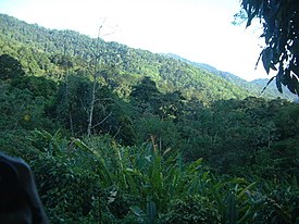
El Cerro del Aripo[1] (940 msnm) es el punto más alto de la República de Trinidad y Tobago.[2] Forma parte del macizo de Aripo y está situado en la Cordillera del Norte de la isla de Trinidad, al nordeste de la localidad de Arima.
| Cerro del Aripo | ||
|---|---|---|
 | ||
| Localización geográfica | ||
| Continente | América | |
| Cordillera | Cordillera del Norte | |
| Coordenadas | 10°43′00″N 61°15′00″O | |
| Localización administrativa | ||
| País |
| |
| División | Trinidad y Tobago | |
| Características generales | ||
| Altitud | 940 m | |
| Prominencia | 940 m | |
Véase también
- Geografía de Trinidad y Tobago
- Geografía de América
Referencias
- http://www.peakbagger.com/peak.aspx?pid=8241
- Dominique De-Light, Polly Thomas: The Rough Guide to Trinidad and Tobago. Rough Guides 2001, ISBN 1858287472, p. 167
Enlaces externos
| Control de autoridades |
|---|
 Datos: Q1056103
 Multimedia: El Cerro del Aripo / Q1056103
На других языках
[de] Cerro del Aripo
Der Cerro del Aripo ist mit 940 m der höchste Berg in Trinidad und Tobago.[en] El Cerro del Aripo
El Cerro del Aripo, at 940 metres (3,084 ft), is the highest point in the Republic of Trinidad and Tobago. It is part of the Aripo Massif and is located in the Northern Range on the island of Trinidad, northeast of the town of Arima.- [es] Cerro del Aripo
[fr] Cerro del Aripo
El Cerro del Aripo est une montagne de Trinité-et-Tobago, le point culminant du pays. Elle se situe à une altitude de 940 mètres à la limite des régions de Tunapuna-Piarco et Sangre Grande.Текст в блоке "Читать" взят с сайта "Википедия" и доступен по лицензии Creative Commons Attribution-ShareAlike; в отдельных случаях могут действовать дополнительные условия.
Другой контент может иметь иную лицензию. Перед использованием материалов сайта WikiSort.org внимательно изучите правила лицензирования конкретных элементов наполнения сайта.
Другой контент может иметь иную лицензию. Перед использованием материалов сайта WikiSort.org внимательно изучите правила лицензирования конкретных элементов наполнения сайта.
2019-2025
WikiSort.org - проект по пересортировке и дополнению контента Википедии
WikiSort.org - проект по пересортировке и дополнению контента Википедии