geo.wikisort.org - Mountains
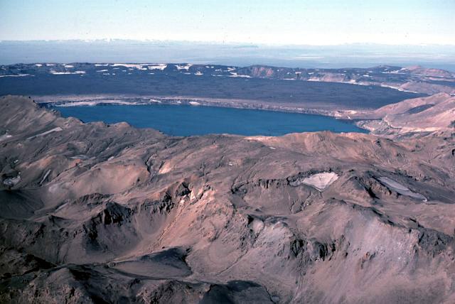
Öskjuvatn (Icelandic pronunciation: [ˈœscʏˌvahtn̥], "Askja Lake") is a lake in the Highlands of Iceland. Its surface area is about 11 km². With a depth of 217 m (712 ft), it is the second deepest lake in Iceland after Jökulsárlón.[1][2]
| Öskjuvatn | |
|---|---|
 | |
 Öskjuvatn | |
| Coordinates | 65°02′N 16°45′W |
| Basin countries | Iceland |
| Surface area | 11 km2 (4.2 sq mi) |
| Max. depth | 217 m (712 ft)[1] |
| Water volume | 1.2 km3 (0.29 cu mi) |
The lake is situated in the crater of the volcano Askja in the north-east of the glacier Vatnajökull. The name Öskjuvatn simply means Askja lake. Like the neighbouring crater Víti, it was created by an enormous volcanic eruption in 1875.[citation needed]
On July 10, 1907, two German scientists, Walter von Knebel and Max Rudloff disappeared while exploring the lake in a small boat. Knebel's fiancée, Ina von Grumbkow, led an expedition in search of them with a vulcanologist Hans Reck, but no trace of them was ever found. Suppositions at the time suggested that seismic volcanic disturbances could have caused a landslip or similar occurrence, and recorded that only two days previously the telegraph cable to Iceland had been broken by deep water disturbances for the first time since it was laid, close to the Icelandic coast.[citation needed]
See also
- Geography of Iceland
- Iceland plume
- List of lakes of Iceland
- List of rivers of Iceland
- Volcanism of Iceland
References
- "Rivers and Lakes". Iceland.is. Retrieved 19 April 2010.
- "Jökulsárlón become the country's deepest lake". Visir. Retrieved 2012-01-04.
External links
| Authority control |
|
|---|
На других языках
[de] Öskjuvatn
Das Öskjuvatn (deutsch: Calderensee) ist ein See im isländischen Hochland. Seine Fläche beträgt ca. 11 km². Die Seetiefe beträgt maximal 220 m.- [en] Öskjuvatn
[fr] Öskjuvatn
Öskjuvatn est un lac situé sur les Hautes Terres d'Islande.[it] Öskjuvatn
Il lago Öskjuvatn si trova negli Altopiani d'Islanda, nella regione centrosettentrionale di Norðurland eystra.[ru] Эскьюватн
Эскьюватн[1] (исл. Öskjuvatn) — кратерное озеро в Исландии, расположено в кальдере вулкана Аскья в восточной части лавового плато Оудаудахрёйн (к северу от ледника Ватнайёкюдль, на территории одноимённого национального парка).Другой контент может иметь иную лицензию. Перед использованием материалов сайта WikiSort.org внимательно изучите правила лицензирования конкретных элементов наполнения сайта.
WikiSort.org - проект по пересортировке и дополнению контента Википедии