geo.wikisort.org - Mountains
Wind Mountain is a 1,907-foot-elevation (581-meter) summit located in Skamania County of Washington state.[3]
| Wind Mountain | |
|---|---|
 West aspect | |
| Highest point | |
| Elevation | 1,907 ft (581 m)[1] |
| Prominence | 947 ft (289 m)[1] |
| Isolation | 2.41 mi (3.88 km)[2] |
| Coordinates | 45°42′36″N 121°45′21″W[3] |
| Geography | |
 Wind Mountain Location of Wind Mountain in Washington  Wind Mountain Wind Mountain (the United States) | |
| Location | Skamania County, Washington, U.S. |
| Parent range | Cascade Range |
| Topo map | USGS Carson |
| Geology | |
| Age of rock | late Miocene to Pliocene |
| Mountain type | intrusive igneous |
| Type of rock | quartz diorite |
| Climbing | |
| First ascent | Native Americans |
| Easiest route | class 1 hiking trail |
 | |
Description
Wind Mountain is part of the Cascade Range and is set within the Columbia River Gorge, on land managed by Gifford Pinchot National Forest. The prominent landmark is situated three miles east of Carson, Washington, and two miles east of the mouth of Wind River. Precipitation runoff from Wind Mountain drains into the Columbia River. Topographic relief is significant as the south aspect rises 1,800 feet (549 meters) above the Columbia in one-half mile. Access to the mountain is via Washington State Route 14 and the 1.4-mile Wind Mountain Trail. From the summit there are views of Greenleaf Peak and Table Mountain to the west, as well as Dog Mountain to the east. The Wind Mountain Spirit Quest is a sacred archeological site near the summit created by Native American youths and dates back to 1000–200 years ago.[4] This geographical feature's name has been officially adopted by the U.S. Board on Geographic Names,[3] noting that the mountain is located in an area known for consistently high winds channeling through the Columbia River Gorge. According to Native American mythology, the Great Spirit set whirlwinds blowing in constant fury around Wind Mountain as punishment for those who had broken a taboo and taught white men how to snare salmon.[5] The Lewis and Clark Expedition visited this area on October 30, 1805, where they observed a submerged forest at the base of this mountain, a relic of the Bonneville landslide which occurred six miles downstream.[6]
Climate
Wind Mountain is located in the marine west coast climate zone of western North America.[7] Most weather fronts originate in the Pacific Ocean, and travel east toward the Cascade Mountains. As fronts approach, they are forced upward by the peaks of the Cascade Range (Orographic lift), causing them to drop their moisture in the form of rain or snowfall onto the Cascades. During winter months, weather is usually cloudy, but due to high pressure systems over the Pacific Ocean that intensify during summer months, there is often little or no cloud cover during the summer.
Gallery
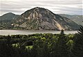 Wind Mountain seen from the Oregon side of the Columbia River
 Columbia River and the top of Wind Mountain seen from the slopes of Dog Mountain
 View from atop Wind Mountain looking west at the confluence of the Wind River (right) and the Columbia River (center).
 The trail on Wind Mountain passing through Douglas fir and swordfern
 Southeast aspect of Wind Mountain seen from Starvation Ridge
 Wind Mountain seen from Dog Mountain


See also
- Geology of the Pacific Northwest
- Lewis and Clark National Historic Trail
References
- "Wind Mountain, Washington". Peakbagger.com.
- "Wind Mountain - 1,907' WA". listsofjohn.com. Retrieved 2022-04-03.
- "Wind Mountain". Geographic Names Information System. United States Geological Survey, United States Department of the Interior. Retrieved 2022-04-03.
- Lauren Braden (2022), 52 Ways to Nature: Washington, Skipstone Pub., ISBN 978-1-68051-313-4
- Federal Writers' Project (2013), The WPA Guide to Oregon, Trinity University Press, ISBN 9781595342355
- USGS.gov
- Beckey, Fred W. Cascade Alpine Guide, Climbing and High Routes. Seattle, WA: Mountaineers Books, 2008.
External links
- Weather forecast: Wind Mountain
- NGS Data Sheet
- Wind Mountain: Columbiariverimages.com
Другой контент может иметь иную лицензию. Перед использованием материалов сайта WikiSort.org внимательно изучите правила лицензирования конкретных элементов наполнения сайта.
WikiSort.org - проект по пересортировке и дополнению контента Википедии