geo.wikisort.org - Mountains
Whorl Mountain is a mountain in the northern part of Yosemite National Park, well north of Mount Conness, and barely inside the boundary of Yosemite. Whorl Mountain is the 22nd-highest mountain in Yosemite National Park.[4]
| Whorl Mountain | |
|---|---|
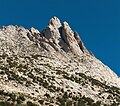
 North aspect, from Matterhorn Peak | |
| Highest point | |
| Elevation | 12,039 ft (3,669 m) NAVD 88[1] |
| Prominence | 673 ft (205 m)[1] |
| Coordinates | 38°04′27″N 119°23′00″W[2] |
| Geography | |
 Whorl Mountain Whorl Mountain  Whorl Mountain Whorl Mountain (the United States) | |
| Location |
|
| Parent range | Ritter Range |
| Topo map | USGS Matterhorn Peak |
| Climbing | |
| First ascent | July 9,1933 by Herbert Blanks, Kenneth May and Eliot Sawyer[3] |
| Easiest route | Exposed scramble, class 3.[3] |
Whorl Mountain is 1.3 miles (2.1 km) south of Matterhorn Peak.[5] Bath Mountain is 4.6 miles (7.4 km) west-south-west, and Excelsior Mountain is 5.5 miles (8.9 km) to the southeast.
On climbing Whorl Mountain
Whorl Mountain is a class 3 climb.[3]
Gallery
 Whorl Mountain summit
 South aspect


References
- "Whorl Mountain, California". Peakbagger.com. Retrieved 2019-03-13.
- "Whorl Mountain". Geographic Names Information System. United States Geological Survey. Retrieved 2021-11-19.
- Secor, R. J. (1997). The High Sierra: Peaks, Passes and Trails (1st ed. revised). Seattle: The Mountaineers Books. ISBN 978-0898869712.
- "Yosemite NP Peaks". Peakbagger.com. Retrieved 2021-11-19.
- "Whorl Mountain". SummitPost.org. Retrieved 2021-11-19.
External links and references
Текст в блоке "Читать" взят с сайта "Википедия" и доступен по лицензии Creative Commons Attribution-ShareAlike; в отдельных случаях могут действовать дополнительные условия.
Другой контент может иметь иную лицензию. Перед использованием материалов сайта WikiSort.org внимательно изучите правила лицензирования конкретных элементов наполнения сайта.
Другой контент может иметь иную лицензию. Перед использованием материалов сайта WikiSort.org внимательно изучите правила лицензирования конкретных элементов наполнения сайта.
2019-2025
WikiSort.org - проект по пересортировке и дополнению контента Википедии
WikiSort.org - проект по пересортировке и дополнению контента Википедии