geo.wikisort.org - Mountains
The Wannig (also Hochwannig or Wanneck) is a 2,493-metre-high mountain in the Mieming Chain in the Austrian state of Tyrol.
| Wannig | |
|---|---|
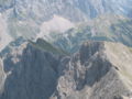
 Wannig (the lower peak on the right) seen from the Nassereither Alm | |
| Highest point | |
| Elevation | 2,493 m (AA) (8,179 ft) |
| Prominence | 704 m (2,310 ft)[1] |
| Coordinates | 47°20′15″N 10°51′45″E |
| Geography | |
 Wannig Location in the Alps | |
| Location | Tyrol, Austria |
| Parent range | Mieming Chain |
| Geology | |
| Type of rock | Wetterstein limestone |
| Climbing | |
| First ascent | first recreational ascent: L. Höß, G. Beyrer on 28 August 1894 via the Handschuhspitzen |
| Normal route | Fern Pass – Nassereither Alm – Wannig |
Location
The Wannig forms the western end of the Mieming Range. To the southwest lies the village of Nassereith in the Gurgltal valley, to the south is the Holzleiten Saddle that links the Gurgltal with the Mieming Plateau. To the north lies the Fern Pass, a crossing from the Gurgltal to Biberwier in the Ehrwald Basin. To the east the Mieming Chain continues with the Handschuhspitzen and the Marienbergjoch (1,789 m).
The upper 400m of the Wannig are characterised by crags and boulder fields, below which is a wide belt of mountain pine. In the lower regions of its western and southern slopes are the remains of old mine workings. Here in the Feigenstein Field (Revier Feigenstein), lead and zinc ore (Smithsonite) was mined.
Ascents
The Wannig is usually climbed from the Nassereither Alm (1,718 m, also called the Muthenaualm) to the northwest, which can be reached from the Fern Pass, from Albangerle north of Nassereith, from Biberwier or from the Marienbergjoch. This route runs across the western flank, the Green Wanne (Grüne Wanne), to the summit (UIAA grade I in places). Another route from Nassereith meets this path at a height of about 1,780 m.
From the Marienbergjoch the Wannig can be climbed from the Handschuhspitzen (UIAA I); other ascents along the north arête (UIAA I) and the north face (UIAA III) are rarely used.
Literature
Rudolf Wutscher (1989), Österreichischer Alpenverein; Deutscher Alpenverein; Alpenverein Südtirol (eds.), Alpenvereinsführer Mieminger Kette (in German), München: Bergverlag Rudolf Rother, pp. 160–161, ISBN 3-7633-1099-1
References
- "Wannig - Peakbagger". peakbagger.com. Retrieved 2 February 2015.
External links
Peter Simon. "Das Bergbaurevier Feigenstein". Kulturverein und Arbeitsgemeinschaft historischer Bergbau Nassereith. Retrieved 12 September 2008.
 The Handschuhspitzen seen from the Wannig
 Nassereith seen from the Wannig
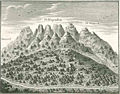 Mining on the Wannig in a copperplate from the 18th century


На других языках
[de] Wannig (Berg)
Der Wannig (auch Hochwannig oder Wanneck) ist ein 2.493 m hoher Gipfel der Mieminger Kette in Tirol.- [en] Wannig
[fr] Wannig
Le Wannig ou Wanneck est un sommet des Alpes, à 2 493 m d'altitude, dans le Wetterstein, et en particulier dans le chaînon de Mieming, en Autriche (land du Tyrol).Другой контент может иметь иную лицензию. Перед использованием материалов сайта WikiSort.org внимательно изучите правила лицензирования конкретных элементов наполнения сайта.
WikiSort.org - проект по пересортировке и дополнению контента Википедии