geo.wikisort.org - Mountains
Veľký Rozsutec (1,609.7 m; 5,281.17 ft AMSL) is a mountain situated in the Malá Fatra mountain range in the Žilina Region, Slovakia. The peak is situated in the north part of Malá Fatra called Krivánska Malá Fatra and is part of the Malá Fatra National Park and Rozsutec National Nature Reserve (since 1967).
| Veľký Rozsutec | |
|---|---|
 Veľký Rozsutec as seen from the Poludňový Grúň (1,460 m) Mountain | |
| Highest point | |
| Elevation | 1,609.7 m (5,281 ft) |
| Coordinates | 49°13′52″N 19°06′00″E |
| Geography | |
 Veľký Rozsutec Location in Slovakia | |
| Location | Žilina Region, Slovakia |
| Parent range | Malá Fatra |
| Climbing | |
| Easiest route | Start from the settlement of Štefanová (625 m), go through the pass of Medziholie (1,185 m) and follow the green trail (green blazes) to the summit. The ascent takes about two and a half hours. |
Veľký Rozsutec and the surrounding area are home to many endangered species of plants and animals, some of which are endemic, as well as rare karst terrain.
Photogallery
 Veľký Rozsutec from Stoh hillside
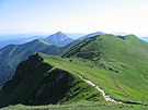 Crest of Malá Fatra with Veľký Rozsutec in the end
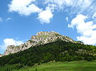 Veľký Rozsutec from Medziholie
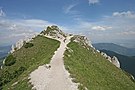 Peak of Veľký Rozsutec
 Veľký Rozsutec from Poludňový grúň


External links
Wikimedia Commons has media related to Veľký Rozsutec.
- Rozsutec National Nature Reserve at the State Inventory of Specially Protected Parts of Nature and Landscape
- 3D panorama from top 20.9.2007
| Authority control: National libraries |
|---|
This Žilina Region geography article is a stub. You can help Wikipedia by expanding it. |
На других языках
[de] Veľký Rozsutec
Der Veľký Rozsutec ist ein Berg in der Kleinen Fatra in der Slowakei.- [en] Veľký Rozsutec
[ru] Вельки-Розсутец
Вельки-Розсутец (Большой Розсутец) — горная вершина в Словакии.Текст в блоке "Читать" взят с сайта "Википедия" и доступен по лицензии Creative Commons Attribution-ShareAlike; в отдельных случаях могут действовать дополнительные условия.
Другой контент может иметь иную лицензию. Перед использованием материалов сайта WikiSort.org внимательно изучите правила лицензирования конкретных элементов наполнения сайта.
Другой контент может иметь иную лицензию. Перед использованием материалов сайта WikiSort.org внимательно изучите правила лицензирования конкретных элементов наполнения сайта.
2019-2026
WikiSort.org - проект по пересортировке и дополнению контента Википедии
WikiSort.org - проект по пересортировке и дополнению контента Википедии