geo.wikisort.org - Mountains
The Vermio Mountains (Greek: Βέρμιο), known in antiquity as the Bermion (Greek: Βέρμιον), is a mountain range in northern Greece. It lies between the Imathia Regional Unit of the Central Macedonia Region and the Kozani Regional Unit of the Western Macedonia Region. The range is west of the plain of Kambania. The town of Veria, which is the capital of Imathia, is built on the foot of these mountains. The highest point in the range is the peak Chamiti (Greek: Χαμίτη), 2,065 metres (6,775 ft) elevation, west of Naousa. In Turkish the mountain is known as Karatash (Karataş), and in Bulgarian it is known as Karakamen (Каракамен).
| Vermio | |
|---|---|
| Βέρμιο | |
 | |
| Highest point | |
| Elevation | 2,065 m (6,775 ft)[1] |
| Coordinates | 40°37′26″N 21°56′33″E |
| Geography | |
 Vermio Location in Greece | |
| Location | Imathia, Greece |
The Vermio Mountains are the site of ski resorts such as Seli and Tria Pente Pigadia.
It was mentioned in antiquity by Pliny,[2] Strabo,[3] Stephen of Byzantium,[4] Hierocles,[5] Ptolemy,[6] and Thucydides[7] and Herodotus.[8][9] In classical times the mountain was thought by Herodotus to be impassible and according to tradition, paradise was to be held on the other side. During Hellenistic times was an internal boundary of the Macedonian state.[10]
Gallery
 Landscape
 Panagia Paramythia Monastery
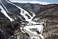 Ski resort


References
- "Oreivatein list of mountain peaks". Archived from the original on October 16, 2013. Retrieved March 22, 2012.
{{cite web}}: CS1 maint: unfit URL (link) - Pliny the Elder, Natural History IV.10
- Strabo VII.26.
- John Anthony Cramer, A geographical and historical description of ancient Greece (1828) p233.
- John Anthony Cramer, A geographical and historical description of ancient Greece (1828)p233.
- Ptol. iii. 12
- George Grote, History of Greece: I. Legendary Greece. II. Grecian History to the Reign of Peisistratus at Athens, Volume 6 (J. Murray, 1854) p98-99.
- Fitz Hugh Ludlow, David M. Gross, The Annotated Hasheesh Eater (David M Gross, 4 Oct. 2007) p95.
- George Grote, A History of Greece: From the Earliest Period to the Close of the Generation Contemporary with Alexander the Great, Volume 4 (J. Murray, 1862) p205-206.
- John Anthony Cramer, A geographical and historical description of ancient Greece (1828) p192.
External links
- Greek Mountain Flora
- Encyclopædia Britannica entry (subscription required)
- Vermio terrain map by Geopsis
На других языках
[de] Vermio (Berg)
Vermio (neugriechisch Βέρμιο (n. sg.), altgriechisch Βέρμιον .mw-parser-output .Latn{font-family:"Akzidenz Grotesk","Arial","Avant Garde Gothic","Calibri","Futura","Geneva","Gill Sans","Helvetica","Lucida Grande","Lucida Sans Unicode","Lucida Grande","Stone Sans","Tahoma","Trebuchet","Univers","Verdana"}Bermion, slawisch Каракамен) ist ein Gebirge im griechischen Makedonien. Früher wurde es auch Doxa (Δόξα) genannt.[1] Es liegt im Gebiet der Regionalbezirke Imathia, Kozani und Pella.- [en] Vermio Mountains
[fr] Vermion
Le Vermion ou Vérmio (en grec moderne : Βέρμιο) est un massif qui sépare la Macédoine-Centrale de la Macédoine-Occidentale, en Grèce. Le point culminant s'élève à 2 065 m.[ru] Вермион
Ве́рмион[1], Бермий[2] (греч. Βέρμιον) — горы в Греции. Расположены в Македонии, в периферийных единицах Иматии и Пеле в периферии Центральной Македонии и в периферийной единице Козани в периферии Западной Македонии. Высочайший пик называется Цанакци, имеет высоту 2052 метра и находится близ Наусы[1].Другой контент может иметь иную лицензию. Перед использованием материалов сайта WikiSort.org внимательно изучите правила лицензирования конкретных элементов наполнения сайта.
WikiSort.org - проект по пересортировке и дополнению контента Википедии