geo.wikisort.org - Mountains
Unicorn Peak is a 5,100-foot-elevation (1,554 meter) mountain summit located within Olympic National Park in Clallam County of Washington state. Unicorn Peak is situated seven miles southwest of Port Angeles and three miles north-northwest of the park's Hurricane Ridge visitor center, in Daniel J. Evans Wilderness. Precipitation runoff from the mountain drains west to the Elwha River via Little River and Griff Creek. Topographic relief is significant as the west aspect rises 4,800 feet (1,463 meters) above the Elwha valley in approximately three miles.
| Unicorn Peak | |
|---|---|
 South aspect, as viewed from Hurricane Hill | |
| Highest point | |
| Elevation | 5,100 ft (1,554 m)[1] |
| Prominence | 650 ft (200 m)[2] |
| Parent peak | Hurricane Hill (5,757 ft)[2] |
| Isolation | 1.47 mi (2.37 km)[2] |
| Coordinates | 48°00′39″N 123°31′20″W[3] |
| Geography | |
 Unicorn Peak Location of Unicorn Peak in Washington  Unicorn Peak Unicorn Peak (the United States) | |
| Location | Olympic National Park Clallam County, Washington, US |
| Parent range | Olympic Mountains |
| Topo map | USGS Elwha |
| Geology | |
| Age of rock | Eocene |
| Climbing | |
| Easiest route | class 3 scrambling[1] |
History
This landform has also been called "Unicorn Peaks",[3] and "The Pinchers",[4] as in crab pinchers. This refers to the appearance of the summit and a 5,050-foot-elevation peak on the peak's northeast aspect, which is known as "Unicorn Horn".[4] Klallam legend has it that during a great flood, canoes were tied to the mountaintop which broke off leaving only the two peaks, and the canoes and people in them floated to where Seattle is located.[4]
Climate
Based on the Köppen climate classification, Unicorn Peak is located in the marine west coast climate zone of western North America.[5] Most weather fronts originate in the Pacific Ocean, and travel east toward the Olympic Mountains. As fronts approach, they are forced upward by the peaks of the Olympic Range, causing them to drop their moisture in the form of rain or snowfall (Orographic lift). As a result, the Olympics experience high precipitation, especially during the winter months. During winter months, weather is usually cloudy, but due to high pressure systems over the Pacific Ocean that intensify during summer months, there is often little or no cloud cover during the summer. The months May through September offer the most favorable weather for viewing or climbing this peak.[1]
Geology
The Olympic Mountains are composed of obducted clastic wedge material and oceanic crust, primarily Eocene sandstone, turbidite, and basaltic oceanic crust.[6] The mountains were sculpted during the Pleistocene era by erosion and glaciers advancing and retreating multiple times.
See also
- Olympic Mountains
- Geology of the Pacific Northwest
Gallery
 West aspect of Unicorn Peak seen from Elwha Valley.
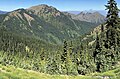 Hurricane Hill (left) and Unicorn Peak (right) seen from Hurricane Ridge.
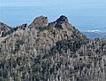 Unicorn Peak (left) and Unicorn Horn (right) seen from Hurricane Hill,
with Port Angeles and Strait of Juan de Fuca in the distance. Unicorn Peak (upper left) from Hurricane Ridge
 Unicorn Peak (left) and Unicorn Horn (right)
 Unicorn Peak seen from Hurricane Hill,
with Strait of Juan de Fuca in the distance.


References
- Unicorn Peak, climbersguideolympics.com
- "Unicorn Peak - 5,125' WA". listsofjohn.com. Retrieved 2021-12-29.
- "Unicorn Peak". Geographic Names Information System. United States Geological Survey. Retrieved 2021-12-29.
- Parratt, Smitty (1984). Gods and Goblins: A Field Guide to Place Names of Olympic National Park (1st ed.).
- Peel, M. C.; Finlayson, B. L.; McMahon, T. A. (2007). "Updated world map of the Köppen−Geiger climate classification". Hydrol. Earth Syst. Sci. 11: 1633–1644. ISSN 1027-5606.
- Alt, D.D.; Hyndman, D.W. (1984). Roadside Geology of Washington. pp. 249–259. ISBN 0-87842-160-2.
External links
- "Olympic National Park". National Park Service.
- Weather forecast: Unicorn Peak
Places adjacent to Unicorn Peak (Olympic Mountains) | ||||||||||||||||
|---|---|---|---|---|---|---|---|---|---|---|---|---|---|---|---|---|
| ||||||||||||||||
Другой контент может иметь иную лицензию. Перед использованием материалов сайта WikiSort.org внимательно изучите правила лицензирования конкретных элементов наполнения сайта.
WikiSort.org - проект по пересортировке и дополнению контента Википедии