geo.wikisort.org - Mountains
Tullparaju[2][3][1][4] (possibly from Quechua tullpa rustic cooking-fire, stove, rahu snow, ice, mountain with snow)[5][6] is a mountain in the Cordillera Blanca in the Andes of Peru, about 5,787 metres (18,986 ft) high.[2][3][1][4] It is situated in the Ancash Region, Huaraz Province, Independencia District, and in the Huari Province, Huari District.[7] Tullparaju lies southeast of the mountains Pucaranra and Chinchey and northeast of Andavite. It is situated at the end of the Quilcayhuanca valley, northeast of the lake Tullpacocha.
| Tullparaju | |
|---|---|
 Tullparaju mountain from the entrance of Quilcayhuanca ravine | |
| Highest point | |
| Elevation | 5,787 m (18,986 ft)[1] |
| Coordinates | 9°24′00″S 77°19′00″W |
| Geography | |
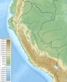 Tullparaju Location in Peru | |
| Location | Peru, Ancash |
| Parent range | Cordillera Blanca |
| Climbing | |
| First ascent | 1-1962 via W. ridge: E. ridge-1979[1] |
Sources
- Neate, Jill (1994). "Peru". Mountaineering in the Andes (PDF). RGS-IBG Expedition Advisory Centre. p. 12. ISBN 0-907649-64-5.
- Alpenvereinskarte 0/3b. Cordillera Blanca Süd (Peru). 1:100 000. Oesterreichischer Alpenverein. 2005. ISBN 3-937530-05-3.
- "Tullparaju - Peakbagger.com". www.peakbagger.com. Retrieved 2016-06-23.
- Ricker, John (1977). Yuraq Janka: A Guide to the Peruvian Andes. The Mountaineers Books. p. 99.
- Vocabulario comparativo quechua ecuatoriano - quechua ancashino -- castellano - English (pdf)
- babylon.com Archived 2014-12-29 at the Wayback Machine
- escale.minedu.gob.pe - UGEL map of the Huaraz Province (Ancash Region) showing the contours of Tullparaju southeast of Chinchey
This Ancash Region geography article is a stub. You can help Wikipedia by expanding it. |
На других языках
- [en] Tullparaju
[fr] Tullparaju
Le Tullparaju[3],[4],[5] (du quechua : tullpa « foyer, cuisine rustique », et rahu « neige, glace » ; littéralement « montagne en forme de foyer »)[6] est une montagne de la cordillère Blanche (Andes) au Pérou. Elle s'élève à une altitude de 5 787 mètres.Текст в блоке "Читать" взят с сайта "Википедия" и доступен по лицензии Creative Commons Attribution-ShareAlike; в отдельных случаях могут действовать дополнительные условия.
Другой контент может иметь иную лицензию. Перед использованием материалов сайта WikiSort.org внимательно изучите правила лицензирования конкретных элементов наполнения сайта.
Другой контент может иметь иную лицензию. Перед использованием материалов сайта WikiSort.org внимательно изучите правила лицензирования конкретных элементов наполнения сайта.
2019-2026
WikiSort.org - проект по пересортировке и дополнению контента Википедии
WikiSort.org - проект по пересортировке и дополнению контента Википедии