geo.wikisort.org - Mountains
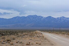
Troy Peak is the highest mountain in the Grant Range in northeastern Nye County, Nevada, United States.[2] It is the thirty-sixth highest mountain in Nevada.[3] Troy Peak also ranks as the third-most topographically prominent peak in Nye County and the fourteenth-most prominent peak in the state.[4] The summit is located 72 miles (116 km) southwest of the city of Ely, within the Grant Range Wilderness of the Humboldt-Toiyabe National Forest.

| Troy Peak | |
|---|---|
 Seen from the White River Valley | |
| Highest point | |
| Elevation | 11,302 ft (3,445 m) NAVD 88[1] |
| Prominence | 4,790 ft (1,460 m)[2] |
| Coordinates | 38°19′10″N 115°30′07″W[1] |
| Geography | |
 Troy Peak | |
| Location | Nye County, Nevada, U.S. |
| Parent range | Grant Range |
| Topo map | USGS Troy Canyon |
| Climbing | |
| Easiest route | Southeast ridge: steep hike/scramble |
References
- "White Pine Reset". NGS data sheet. U.S. National Geodetic Survey. Retrieved 2008-11-24.
- "Troy Peak, Nevada". Peakbagger.com. Retrieved 2011-05-19.
- "Nevada 11,000-foot Peaks". Peakbagger.com. Retrieved 2014-10-22.
- "Nevada Peaks with 2000 feet of Prominence". Peakbagger.com. Retrieved 2014-10-23.
External links
- "Troy Peak". Geographic Names Information System. United States Geological Survey. Retrieved 2008-11-24.
- "Troy Peak". SummitPost.org. Retrieved 2011-05-07.
Текст в блоке "Читать" взят с сайта "Википедия" и доступен по лицензии Creative Commons Attribution-ShareAlike; в отдельных случаях могут действовать дополнительные условия.
Другой контент может иметь иную лицензию. Перед использованием материалов сайта WikiSort.org внимательно изучите правила лицензирования конкретных элементов наполнения сайта.
Другой контент может иметь иную лицензию. Перед использованием материалов сайта WikiSort.org внимательно изучите правила лицензирования конкретных элементов наполнения сайта.
2019-2025
WikiSort.org - проект по пересортировке и дополнению контента Википедии
WikiSort.org - проект по пересортировке и дополнению контента Википедии