geo.wikisort.org - Mountains
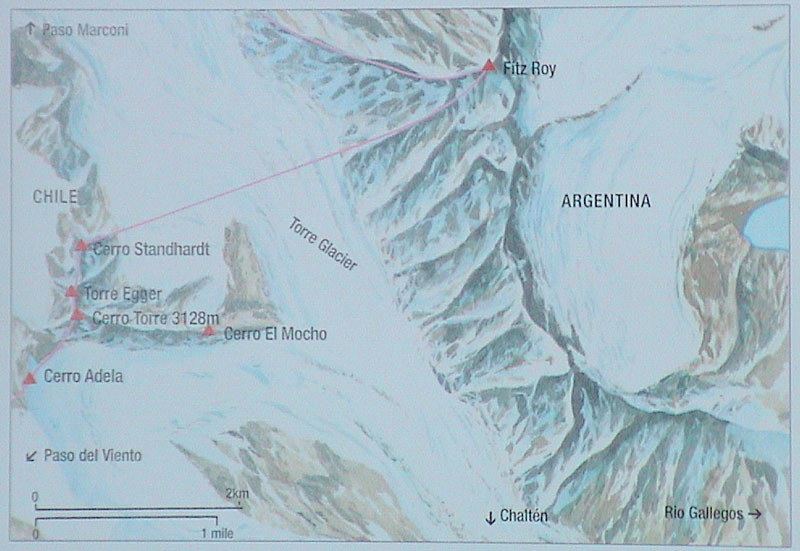
Torre Egger is one of the mountains of the Southern Patagonian Ice Field in South America. It is located in a region which is disputed between Argentina and Chile,[2] west of Cerro Chalten (also known as Fitz Roy). The peak is between Cerro Torre, the highest in a four mountain chain[3] and Cerro Stanhardt. It is named after the Austrian alpinist Toni Egger (1926–1959), who died while attempting neighboring Cerro Torre.

| Torre Egger | |
|---|---|
| Highest point | |
| Elevation | 2,685 m (8,809 ft) |
| Prominence | 275 m (902 ft)[1] |
| Coordinates | 49°17′34″S 73°05′54″W |
| Geography | |
| Location | Patagonia, Argentina, Chile (disputed)[2] |
| Parent range | Andes |
| Climbing | |
| First ascent | February 1976: Bragg, Donini, Wilson (US) |
| Easiest route | rock/snow/ice |
First ascent
In 1976, John Bragg, Jim Donini and Jay Wilson from the United States climbed Torre Egger by climbing first to the col between the peak and Cerro Torre, the Col of Conquest, and then up the ridge to the peak. The ascent was hampered by bad weather and took from December 1975 to February 22, 1976, when the 3-person team summited.[4]
Other ascents
- 1986 Psycho Vertical (Southeast Face) (UIAA ED+ VII+ A3 90deg, 950m) Janez Jeglič, Silvo Karo, Franc Knez (Slovenia), December 7, 1986.[5]
- 1987 Titanic (East Pillar) (UIAA VI+ A2 7b M5 WI4, 950m), Maurizio Giarolli and Elio Orlandi (Italy), November 2 to 5, 1987.[6]
- 1994 Badlands (YDS VI 5.10 A3 WI4+, 1000m) Conrad Anker, Jay Smith and Steve Gerberding (US), FA 12 December 1994.[7]
- 2005 Titanic (East Pillar) (UIAA VI+ A2 7b M5 WI4, 950m) Steph Davis, Dean Potter. The first female ascent of Torre Egger and likely the first one-day ascent of the mountain.[8][9][10]
- 2012 Die another day (west face) (UIAA VIII A1) Matteo Bernasconi, Matteo Della Bordella. The route ends 25m below Col de Lux.
- 2013 Notti Magiche (West face) (UIAA VIII A1) Matteo Della Bordella, Luca Schiera. From Col de Lux to the top, followed the Huber-Sharf, 200m of rock and ice.[11]
- 2016 Titanic (East Pillar) (UIAA VI+ A2 7b M5 WI4, 950m) Marc-André Leclerc. First winter solo.[12]
In January 2008, Rolando Garibotti and Colin Haley made the first complete traverse of the entire massif, climbing Aguja Standhardt, Punta Herron, Torre Egger and Cerro Torre together. They rate their route at YDS VI 5.11 A1 WI6 Mushroom Ice 6, with 2,200 m (7,200 ft) total vertical gain. This had been "one of the world's most iconic, unclimbed lines", first attempted by Ermanno Salvaterra.[13]
References
- "Torre Egger, Argentina". Peakbagger.com. Retrieved 2014-06-10. Note: The prominence value given here was calculated from the difference between an elevation of 2850m for Torre Egger and 2575m for Col de la Conquista, the key col for Torre Egger.
- From Rodrigo Jordan, "Cerro Torre", in World Mountaineering, Audrey Salkeld, editor, Bulfinch Press, ISBN 0-8212-2502-2, p. 156: Cerro Torre rises "on the border between Chile and Argentina." However Chile and Argentina have long-standing border disputes.
- Torre Egger 2005, Huberbuam Archived 2009-05-11 at the Wayback Machine
- Bragg, John (1977). "Torre Egger". American Alpine Journal. New York: American Alpine Club. 21 (51): 49–56. ISBN 978-0-930410-31-5.
- Karo, Silvo (1988). "Torre Egger's Southeast Face". American Alpine Journal. New York: American Alpine Club. 30 (62): 49–51. ISBN 978-0-930410-33-9.
- Orlandi, Elio (1988). "The Eastern Pillar of Torre Egger". American Alpine Journal. New York: American Alpine Club. 30 (62): 52–55. ISBN 978-0-930410-33-9.
- "Cerro y Agujas del Cordon Torre". Climbing in Patagonia. Archived from the original on 2009-06-20. Retrieved 2009-05-27.
- "Wild Times in Patagonia". 14 March 2005.
- "Against the odds". TheGuardian.com. 5 May 2007.
- Steph Davis (2005-06-01). "Cerro Standhardt, New Route, Torre Egger, First One-Day And First Female Ascent". Alpinist.com. Retrieved 2022-08-12.
- "EpicTV | Matteo della Bordella Describes First Route on West Face, Torre Egger, Patagonia - EpicTV". Archived from the original on 2013-12-12. Retrieved 2013-12-12.
- Carpenter, Hayden (28 September 2016). "Marc-André Leclerc Solos Patagonia's Torre Egger in Winter". Rock and Ice. Retrieved 1 June 2019.
- Garibotti, Rolando (September 2008). "The Torre Traverse". Alpinist. Jackson, Wyoming: Alpinist Magazine. 2008 (25): 52–59.
External links
На других языках
[de] Torre Egger
Der Torre Egger ist ein 2880 m,[1] nach anderen Quellen 2850 m[2] oder 2685 m[3] hoher Granitberg, der sich im Campo de Hielo Sur an der argentinisch-chilenischen Grenze befindet, etwa 50 km nördlich des bekannten Nationalparks Torres del Paine.[4] Seinen Namen erhielt der Berg zum Gedenken an Toni Egger, der bei der versuchten Erstbegehung des Cerro Torre 1959 durch eine Lawine getötet wurde.- [en] Torre Egger
[fr] Torre Egger
La Torre Egger est une montagne du champ de glace Sud de Patagonie en Amérique du Sud. Il est situé dans une région disputée entre l'Argentine et le Chili[2]. Il est situé à l'ouest du cerro Chaltén, connu aussi sous le nom de Fitz Roy. Le pic se trouve entre le cerro Torre, le plus haut pic de la chaîne[3] et le cerro Standhardt.[it] Torre Egger
La Torre Egger è una montagna del Campo di ghiaccio Patagonico Sud in Sud America. È situato in una regione contesa tra Argentina e Cile, ad Ovest del monte Fitz Roy. La cima si trova tra Cerro Torre, la più alta tra le quattro montagne della catena, e il Cerro Standhardt. È senza dubbio la montagna più difficile della Patagonia,l'ingaggio per arrivare sulla cima (dalla via "normale") è maggiore di quello per raggiungere la cima del Cerro Torre dalla via dei RagniДругой контент может иметь иную лицензию. Перед использованием материалов сайта WikiSort.org внимательно изучите правила лицензирования конкретных элементов наполнения сайта.
WikiSort.org - проект по пересортировке и дополнению контента Википедии