geo.wikisort.org - Mountains
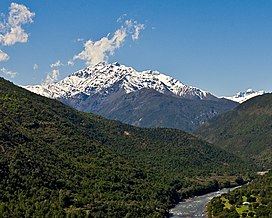
Tinguiririca Volcano is a massive and active stratovolcano located in Chile's VI Region (O'Higgins) and near the Argentinian border. Constant fumarolic activity occurs within and on the NW wall of its summit crater and hot springs and fumaroles can also be seen on the western flanks, as illustrated by the image on the right. It was near this volcano that the Uruguayan Air Force Flight 571 crashed in 1972 with its survivors lost for seventy-two days.
| Tinguiririca Volcano | |
|---|---|
 The Tinguiririca volcano seen from the Tinguiririca river valley. The fumarole from its summit crater can be clearly seen. | |
| Highest point | |
| Elevation | 4,280 m (14,040 ft) |
| Coordinates | 34°48′49″S 70°21′07″W |
| Geography | |
| Location | Chile |
| Parent range | Andes |
| Geology | |
| Mountain type | Stratovolcano |
| Last eruption | 1917 |
See also
References
- "Tinguiririca". Global Volcanism Program. Smithsonian Institution.
На других языках
- [en] Tinguiririca Volcano
[es] Volcán Tinguiririca
El Tinguiririca es un volcán activo, en estado temporalmente pasivo, de 4260 msnm de altitud, localizado en la Zona Central de Chile. Es del tipo estratovolcán. Se encuentra cirscuncrito administrativamente a la Región de O'Higgins, Provincia de Colchagua, en la comuna de San Fernando.[fr] Tinguiririca
Le Tinguiririca est un volcan du Chili constitué d'un stratovolcan par-dessus lequel se sont édifiées sept cônes pyroclastiques. Sa seule éruption volcanique connue est celle de 1917 et son activité actuelle est représentée par un panache de fumerolles issu du cratère sommital.Текст в блоке "Читать" взят с сайта "Википедия" и доступен по лицензии Creative Commons Attribution-ShareAlike; в отдельных случаях могут действовать дополнительные условия.
Другой контент может иметь иную лицензию. Перед использованием материалов сайта WikiSort.org внимательно изучите правила лицензирования конкретных элементов наполнения сайта.
Другой контент может иметь иную лицензию. Перед использованием материалов сайта WikiSort.org внимательно изучите правила лицензирования конкретных элементов наполнения сайта.
2019-2025
WikiSort.org - проект по пересортировке и дополнению контента Википедии
WikiSort.org - проект по пересортировке и дополнению контента Википедии