geo.wikisort.org - Mountains
Thierberg is a mountain located in the north and southwest of the town of Kiefersfelden and thus extends over the border between Austria and Germany and it extends up to Bavaria, Germany but the most part is in Tyrol. In the not-too-high mountain, the Inn Valley is located at approximately 500 meters above sea level. There are several lakes: Egelsee, Hechtsee and Längsee.
This article may be expanded with text translated from the corresponding article in German. (June 2010) Click [show] for important translation instructions.
|
| Thierberg | |
|---|---|
 | |
| Highest point | |
| Elevation | 760 m (2,490 ft) |
| Isolation | 1.06 km (0.66 mi) |
| Coordinates | 47°36′00″N 12°09′52″E |
| Geography | |
 Thierberg Bavaria, Germany | |
Thierberg mountain is named after the village and cadastral community "Thierberg" .
On the mountain, the Thierberg castle (721 m.a.s.l) is one of the popular pilgrimage destination of the mountain that was built approximately 1280 A.C.
 Theirberg chapel in the background is Spitzstein (left) and Geigelstein.
 Theirberg chapel (inside).
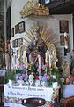 An altar at Theirberg chapel.
 Kaiser Mountains seen from Thierberg.


External links
- (in German) www.thierberg.at
This Bavaria location article is a stub. You can help Wikipedia by expanding it. |
На других языках
[de] Thierberg (Tirol)
Der Thierberg ist ein 721 m ü. A. hoher Berg im Norden der Stadt Kufstein bzw. südwestlich von Kiefersfelden und erstreckt sich somit über die Staatsgrenze zwischen Österreich und Deutschland, liegt aber zum allergrößten Teil in Tirol. Auf dem nicht allzu hohen Berg – das Inntal befindet sich auf rund 500 Meter Seehöhe – befinden sich gleich mehrere Seen: Egelsee, Hechtsee, Längsee und Pfrillsee.- [en] Thierberg
[fr] Thierberg (Tyrol)
Le Thierberg est une colline qui s’élève à 721 m d’altitude dans les Alpes de Brandenberg, au sud-ouest de la ville de Kufstein, en Autriche.Текст в блоке "Читать" взят с сайта "Википедия" и доступен по лицензии Creative Commons Attribution-ShareAlike; в отдельных случаях могут действовать дополнительные условия.
Другой контент может иметь иную лицензию. Перед использованием материалов сайта WikiSort.org внимательно изучите правила лицензирования конкретных элементов наполнения сайта.
Другой контент может иметь иную лицензию. Перед использованием материалов сайта WikiSort.org внимательно изучите правила лицензирования конкретных элементов наполнения сайта.
2019-2026
WikiSort.org - проект по пересортировке и дополнению контента Википедии
WikiSort.org - проект по пересортировке и дополнению контента Википедии