geo.wikisort.org - Mountains
The Thumb is a 13,356-foot-elevation (4,071 meter) mountain summit located on the crest of the Sierra Nevada mountain range, in Inyo County of northern California.[3] It is situated in the Palisades area of the John Muir Wilderness, on land managed by Inyo National Forest. It is 1.3 mile (2.1 km) east of Middle Palisade, 1.6 mile (2.6 km) west-northwest of Birch Mountain, and 1.8 mile (2.9 km) north of Mount Bolton Brown. The Thumb ranks as the 83rd-highest summit in California.[2] Topographic relief is significant as the east aspect rises over 2,500 feet (770 meters) above Birch Lake in approximately one mile. The John Muir Trail traverses below the southwest aspect of the mountain, providing an optional approach access.
| The Thumb | |
|---|---|
| East Palisade | |
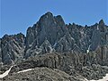
 The Thumb centered, west aspect | |
| Highest point | |
| Elevation | 13,356 ft (4,071 m)[1] |
| Prominence | 594 ft (181 m)[1] |
| Parent peak | Ed Lane Peak (13,577 ft)[2] |
| Isolation | 0.93 mi (1.50 km)[2] |
| Listing | Sierra Peaks Section |
| Coordinates | 37°04′17″N 118°26′46″W[3] |
| Geography | |
 The Thumb Location in California  The Thumb The Thumb (the United States) | |
| Location | Inyo County, California, U.S. |
| Parent range | Sierra Nevada Palisades[1] |
| Topo map | USGS Split Mountain |
| Geology | |
| Age of rock | Cretaceous |
| Mountain type | Fault block |
| Type of rock | granitic |
| Climbing | |
| First ascent | 1921 |
| Easiest route | class 2[2] Southeast slope |
History
The first ascent of the summit was made December 12, 1921, by Windsor B. Putnam via the southeast slope and an approach from Birch Creek. The class 4 northwest face was first climbed June 5, 1930, by Norman Clyde.[4] This mountain's name was submitted for consideration by Windsor B. Putnam, and officially adopted in 1926 by the U.S. Board on Geographic Names.[3] This peak has in the past been called "East Palisade" and "Thumb Peak".[3]
Climate
The Thumb has an alpine climate which supports the Middle Palisade Glacier below the western cliffs.[5] Most weather fronts originate in the Pacific Ocean, and travel east toward the Sierra Nevada mountains. As fronts approach, they are forced upward by the peaks, causing them to drop their moisture in the form of rain or snowfall onto the range (orographic lift). Precipitation runoff from this mountain drains to Owens Valley via Big Pine and Birch Creeks.
Gallery
 Northwest aspect
 Eastern Sierra Nevada from Hwy 168 with The Thumb centered.
 The Thumb visible to right of center


See also
- List of the major 4000-meter summits of California
References
- "The Thumb". Peakbagger.com. Retrieved 2021-06-09.
- "Thumb, The - 13,356' CA". listsofjohn.com. Retrieved 2021-06-09.
- "The Thumb". Geographic Names Information System. United States Geological Survey. Retrieved 2021-06-09.
- Hervey Voge and David R. Brower, A Climber’s Guide to the High Sierra (1954)
- "Climate of the Sierra Nevada". Encyclopædia Britannica.
External links
- Windsor B. Putnam's account of naming and climbing The Thumb: Sierra Club Bulletin
- Weather forecast: The Thumb
Другой контент может иметь иную лицензию. Перед использованием материалов сайта WikiSort.org внимательно изучите правила лицензирования конкретных элементов наполнения сайта.
WikiSort.org - проект по пересортировке и дополнению контента Википедии