geo.wikisort.org - Mountains
The Rectory[1] is a 6,565-ft (2,001 m) sandstone summit in Grand County of Utah, United States. The Rectory is located at Castle Valley, Utah, near the city of Moab. The Rectory is a thin 200 feet (61 m) wide, and 1,000 feet (305 m) long north-to-south butte with 200 ft vertical Wingate Sandstone walls tower standing on a 1,000 foot Moenkopi-Chinle base. Precipitation runoff from The Rectory drains into the nearby Colorado River. The nearest higher peak is Castleton Tower, 0.35 miles (0.56 km) to the south.[1] Priest and Nuns are towers immediately north and part of The Rectory.[2] Further northwest along the connecting ridge is The Convent, with a rock tower called Sister Superior between the two. The first ascent was made May 22, 1962, by Harvey Carter and Cleve McCarty via Empirical Route.[3] Harvey Carter named this geological feature.[4]
| The Rectory | |
|---|---|
 The Rectory (left) and Castleton Tower (right) seen from Utah State Route 128 | |
| Highest point | |
| Elevation | 6,565 ft (2,001 m)[1] |
| Prominence | 405 ft (123 m)[1] |
| Coordinates | 38°39′22″N 109°22′02″W[1] |
| Geography | |
 The Rectory Location in Utah  The Rectory The Rectory (the United States) | |
| Location | Grand County, Utah United States |
| Parent range | Colorado Plateau |
| Topo map | USGS Fisher Towers |
| Geology | |
| Type of rock | Wingate Sandstone |
| Climbing | |
| First ascent | 1962 |
| Easiest route | Climbing class 5.9 |
Climbing Routes
Classic Climbing Routes on The Rectory[5]
- Fine Jade - class 5.11a - 5 pitches
- Ministry - class 5.11a - 5 pitches
- Coyote Calling - class 5.11+ - 4 pitches
- Crack Wars - class 5.11a/b - 4 pitches
- Find Shade - class 5.11 - 4 pitches
- Empirical Route - class 5.9R - 3 pitches
Music Videos
The Jon Bon Jovi music video Blaze of Glory was filmed at The Rectory. The Australian band Heaven also filmed their Knockin' on Heaven's Door music video on top of The Rectory.
Climate
Spring and fall are the most favorable seasons to visit, when highs average 60 to 80 °F (15.5 to 26.6 °C) and lows average 30 to 50 °F (-1.1 to +10 °C). Summer temperatures often exceed 100 °F (37.7 °C). Winters are cold, with highs averaging 30 to 50 °F, and lows averaging 0 to 20 °F (-17.7 to -6.6 °C). As part of a high desert region, it can experience wide daily temperature fluctuations. The area receives an average of less than 10 inches (254 mm) of rain annually.
Gallery
 The Rectory, Priest and Nuns (left)
 The Rectory (left) and Castleton Tower (right)
 The Rectory seen from Fisher Towers


 Crux Pitch of Fine Jade
 The Priest seen from The Rectory
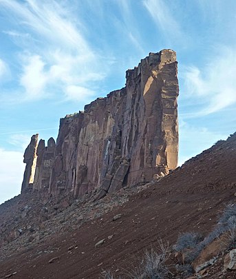 The Rectory, Priest and Nuns to left


References
External links
- Blaze of Glory Jon Bon Jovi's "Blaze of Glory" music video
- Heaven on The Rectory Heaven's music video
- Climbers on The Rectory: PBase photo
- National Weather Service forecast
- Jon Bon Jovi Rocks the Rectory: Moab Times
Places adjacent to The Rectory | ||||||||||||||||
|---|---|---|---|---|---|---|---|---|---|---|---|---|---|---|---|---|
| ||||||||||||||||
На других языках
- [en] The Rectory (Utah)
[fr] The Rectory
The Rectory (littéralement, en français, « le presbytère ») est un sommet de grès rouge, culminant à 2 001 mètres d'altitude dans le comté de Grand, dans l'Utah, aux États-Unis. Il fait partie d'un ensemble de structures rocheuses ayant la même origine, dont les noms anglais d'origine religieuse leur ont été donné par des pionniers Mormons qui s'installèrent dans l'Utah au XIXe siècle sur les terres des terres traditionnelles des Shoshones de l'Est, Hopis, Navajos, Southern Tribus Paiute, Utes et Zuñis[2].Другой контент может иметь иную лицензию. Перед использованием материалов сайта WikiSort.org внимательно изучите правила лицензирования конкретных элементов наполнения сайта.
WikiSort.org - проект по пересортировке и дополнению контента Википедии