geo.wikisort.org - Mountains
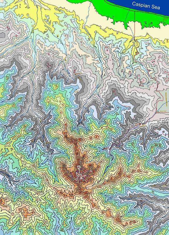
Takht-e Soleyman Massif (Persian: گرانکوه تخت سليمان) is a subrange of central Alborz mountains.[1] In the area, about 160 distinct peaks higher than 4,000m are distinguishable, with the highest, most famous, and most technical one: Alam Kuh, 4,850m. The area can be captured inside a rectangle of 30 km width and 40 km length. The massif is limited to Taleqan valley from south, Kelardasht green plane from east, Abbas Abad rain forest & thick vegetated hills/slopes at north, and Shahsavar rain forests and Se Hezar valley at west.

Discovery
The original and pre Islamic name is Takht-e-Jamshid - The Takht-e-Soleiman region was virtually unknown until the 1930s. Freya Stark travelled there in 1931 and described her thwarted efforts to climb Takht-e Suleyman in The Valleys of the Assassins.[2] Douglas Busk, a British mountaineer, explored the area in 1932,[3] and made the first recorded ascent of Alam Kuh in 1933 via the east ridge.[4] Later on, Busk along with Professor Bobek made a detailed survey of this area. In 1936 the north-west ridge (called Germans flank) of Alam Kuh was climbed for the first time by German mountaineers, which was considered a great achievement among European climbers.
References
- http://images.summitpost.org/original/429880.JPG [bare URL image file]
- Freya Stark, The Valleys of the Assassins and Other Persian Travels (London, 1934)
- D. L. Busk, Climbing and ski-ing in the Elburz Range, North Persia, 1931-2: The Alpine Journal, v. 45, p. 334-341 (1933).
- D. L. Busk, Climbing in the Takht-i-Suleiman Group, N. Persia: The Alpine Journal, v. 47, p. 299-309 (1935).
External links
Authority control | |
|---|---|
| General |
|
| National libraries | |
На других языках
- [en] Takht-e Suleyman Massif
[es] Macizo Tajt-e Soleimán
El macizo Tajt-e Soleimán (en persa: بلندیهای تخت سليمان) es una subcadena de montañas de los montes centrales Elburz. En la región se distinguen alrededor de 160 picos que superan los 4.000 metros de altitud, siendo el más alto, famoso y técnico el Alam Kuh (4.850 m). La región puede insertarse en un rectángulo de 30 km de ancho y 40 de largo. El macizo queda limitado por el valle de Talekán al sur, la llanura verde de Kelardasht al este, el bosque tropical de Abbas Abad y colinas de espera vegetación al norte, y los bosques de Shahsavar y el valle de Se Hezar al oeste.[fr] Massif de Takht-e Soleyman
Le massif de Takht-e Soleyman (persan : گرانکوه تخت سليمان) est un massif de l'Elbourz[1] regroupant près de 160 sommets de plus de 4 000 m d'altitude, dont le plus élevé est l'Alam Kuh avec 4 850 m. Le massif s'étend sur 40 km de longueur et 30 km de largeur. Il est bordé par la vallée de Taléghan au sud, Kelardasht à l'est, la forêt d'Abbas Abad au nord, et les forêts de Tonekabon et la vallée de Se Hezar à l'ouest.Другой контент может иметь иную лицензию. Перед использованием материалов сайта WikiSort.org внимательно изучите правила лицензирования конкретных элементов наполнения сайта.
WikiSort.org - проект по пересортировке и дополнению контента Википедии