geo.wikisort.org - Mountains
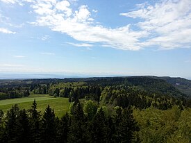
The so-called Table Jura (also Plateau Jura; German: Tafeljura, French: le Jura tabulaire) is the northeastern extension of the Jura Mountains. It stands in opposition to the folded Jura (Faltenjura) of the Jura range proper.
This article does not cite any sources. (November 2017) |
| Table Jura | |
|---|---|
 | |
| Highest point | |
| Peak | Lemberg |
| Elevation | 1,015 m (3,330 ft) |
| Coordinates | 48°09′02″N 8°44′57″E |
| Geography | |
| Countries | Germany and Switzerland |
| Cantons/States | Basel-Landschaft, Aargau, Schaffhausen, Baden-Württemberg and Bavaria |
| Range coordinates | 50°16′N 10°58′E |
The Table Jura stretches across the Swiss cantons of Basel-Landschaft, Aargau, and Schaffhausen (Randen) into southern Germany (Baden-Württemberg, Bavaria), including the Hoher Randen, Baar, the Swabian Jura and the Franconian Jura. The Table Jura thus ranges from near the Swiss city of Basel to the German city of Coburg.
На других языках
[de] Tafeljura
Als Tafeljura bezeichnet man in der Schweiz diejenigen Teile des Schweizer Jura, die im Gegensatz zu dessen aufgefalteten Teilen (Faltenjura) nicht gefaltet wurden. Er ist nicht zu verwechseln mit dem Plateaujura, der mit dem Kettenjura einen Teil des Faltenjura bildet.- [en] Table Jura
Текст в блоке "Читать" взят с сайта "Википедия" и доступен по лицензии Creative Commons Attribution-ShareAlike; в отдельных случаях могут действовать дополнительные условия.
Другой контент может иметь иную лицензию. Перед использованием материалов сайта WikiSort.org внимательно изучите правила лицензирования конкретных элементов наполнения сайта.
Другой контент может иметь иную лицензию. Перед использованием материалов сайта WikiSort.org внимательно изучите правила лицензирования конкретных элементов наполнения сайта.
2019-2025
WikiSort.org - проект по пересортировке и дополнению контента Википедии
WikiSort.org - проект по пересортировке и дополнению контента Википедии