geo.wikisort.org - Mountains
Sugarloaf Mountain is a hiking and mountain biking destination located in Cleburne County, Arkansas, east of the city of Heber Springs, Arkansas, in the foothills of the Ozark Mountains. It is a 690 feet (210 m) erosional remnant beside Little Red River (Arkansas). The mountain is topped by an Atoka formation, a geologic formation sequence of sandstone, siltstone, and shale.

History
The Osage Tribe called the mountain Tonawanda or Ton-Wan-Dah (swift water). The name was that of a family of arrowhead makers.[1]

The earliest settlers called the mountain 'Sugarloaf' because of the resemblance in shape to the loaves of unrefined sugar in use at that time. The Louisiana Purchase survey party in 1819 noted the feature as "encountered Sugar Lofe [sic], a well-known landmark". Natives and travelers on the nearby Little Red River used the mountain as a landmark. The name of the landmark became the name of the springs to the west and the community, Sugarloaf, that developed there. The community's name was later changed to Heber Springs, Arkansas.[2]
Sugarloaf Mountain is located on a section line, and consequently, land transactions have always been conducted in two parcels. For several years, beginning in 1901, the Lucas brothers, Creighton and Richard, maintained a mining claim on the north side of Sugarloaf Mountain, but no ore or oil was discovered. In 1922 L.E. Robbins of Heber Springs, Arkansas purchased 40 acres (160,000 m2) on the south of the mountain along with other land from Richard R. Lucas. In 1951 he acquired a clear title to the 40 acres (160,000 m2) on the north side by patent from the United States government. In the same year of the patent, Robbins and his wife Dotte dedicated 80 acres (320,000 m2) to the town of Heber Springs in a 99-year lease. The lease specified that the land was to be used as a public park and picnic ground, and that the town should have the right to build barbecue grills, tables and benches; it also specified that no lumber should be cut except as prescribed by the Arkansas Forestry Commission, and then only by the grantors or their heirs.[1]

Beginning in March 2002, Arkansas State University, ASU-Beebe, purchased 249 acres on the east side of the city of Heber Springs which included Sugarloaf Mountain. Construction on the ASU-Heber Springs campus at the base of Sugarloaf Mountain was completed in 2007, which consists of the Academic Center and Student Services/Administration Building. The first phase of construction of the campus was completed in 2007. [3]
At the same time, working with Arkansas State University (ASU), the Sugarloaf Heritage Council was established to remove graffiti, restore, enhance, and make additions to the existing trails. Environmentally safe solvents were used to remove the graffiti. Workers suspended by ropes from the side of the mountain used the solvents to clean the graffiti. The trail work took 10 years to complete.[4]
Points of interest
The trails on Sugarloaf Mountain:
- Tonawanda - 1.3 miles around the summit
- Summit - 0.66 miles up 690' to the top
- Hidden Pond - 1 mile paved, ADA compliant
- Wildlife - 1 mile (along Sulphur Creek, looping around Waterfowl Lake)
- Vanguard - 2.6 mile mountain biking and trail running.
Gallery
 Sugarloaf Mountain in Winter
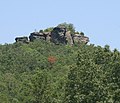 The Original Hard Rock: Sugarloaf Mountain
 Map of Sugarloaf Trails


References
- Berry, Evelena (1983). Time and the river: a history of Cleburne County. Rose Publishing Company. OCLC 9732048.
- "Encyclopedia of Arkansas". EncyclopediaofArkansas.net.
- "Arkansas State University". www.asusystem.edu.
- "Sugarloaf Heritage Council". SugarloafHeritageCouncil.org.
Другой контент может иметь иную лицензию. Перед использованием материалов сайта WikiSort.org внимательно изучите правила лицензирования конкретных элементов наполнения сайта.
WikiSort.org - проект по пересортировке и дополнению контента Википедии