geo.wikisort.org - Mountains
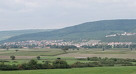
The Stromberg is a heavily forested hill ridge up to 476.6 m above sea level (NN) in the northern part of the German state of Baden-Württemberg.
| Stromberg | |
|---|---|
 Stromberg main chain with the Hohenhaslach in the Kirbach valley and the Brackenheim 1 transmission tower (on the horizon) from the south | |
| Highest point | |
| Peak | Baiselsberg |
| Elevation | 476.6 m above NN |
| Geography | |
| State | counties of Enzkreis, Karlsruhe, Heilbronn and Ludwigsburg, Baden-Württemberg, Germany |
| Range coordinates | 49°00′14″N 8°59′19″E |
| Parent range | South German Scarplands |
| Geology | |
| Orogeny | Schichtstufe |
| Type of rock | Keuper, Reed sandstone, Lower Bunter Marl, Upper Bunter Marl, Stubensandstein |
Literature
- Dieter Buck (2006), Das große Buch vom Stromberg-Heuchelberg. Natur, Kultur, Geschichte, Orte (in German) (1. ed.), Tübingen: Silberburg-Verlag, ISBN 3-87407-704-7
- Karl Eduard Paulus: Beschreibung des Oberamts Brackenheim. Hrsg. von dem Königlichen statistisch-topographischen Bureau. H. Lindemann, Stuttgart 1873, Wikisource
- Karl Eduard Paulus: Beschreibung des Oberamts Vaihingen. Hrsg. von dem Königlichen statistisch-topographischen Bureau. Hallberger, Stuttgart 1856. Wikisource
References
External links
- Natural region fact file Strom- und Heuchelberg (124) – LUBW (pdf, 7,3 MB)
- Map of the Stromberg at: Map services of the Baden-Württemberg State Office for the Environment, Survey and Conservation (Landesanstalt für Umwelt, Messungen und Naturschutz Baden-Württemberg)
- Website of the nature park with information on its geology
- Nature in the Stromberg
На других языках
[de] Stromberg (Landschaft)
Der Stromberg ist ein bis 477,3 m ü. NHN hoher, waldreicher Höhenzug im nördlichen Baden-Württemberg.- [en] Stromberg (landscape)
Текст в блоке "Читать" взят с сайта "Википедия" и доступен по лицензии Creative Commons Attribution-ShareAlike; в отдельных случаях могут действовать дополнительные условия.
Другой контент может иметь иную лицензию. Перед использованием материалов сайта WikiSort.org внимательно изучите правила лицензирования конкретных элементов наполнения сайта.
Другой контент может иметь иную лицензию. Перед использованием материалов сайта WikiSort.org внимательно изучите правила лицензирования конкретных элементов наполнения сайта.
2019-2025
WikiSort.org - проект по пересортировке и дополнению контента Википедии
WikiSort.org - проект по пересортировке и дополнению контента Википедии
