geo.wikisort.org - Mountains
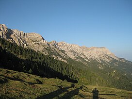
The Serra del Cadí is a mountain range in the north of Catalonia, Spain, part of the Pre-Pyrenees. Its highest peak is the Vulturó, with an altitude of 2,648 metres (8,688 ft).
| Serra del Cadí | |
|---|---|
 View of the Cadí mountain range | |
| Highest point | |
| Peak | Vulturó |
| Elevation | 2,648 m (8,688 ft)[1] |
| Coordinates | 42°17′24.50″N 1°37′08.33″E |
| Dimensions | |
| Length | 22.6 km (14.0 mi) E/W |
| Width | 8 km (5.0 mi) N/S |
| Geography | |
 Serra del Cadí Location in the Pre-Pyrenees area | |
| Country | Spain |
| Community | Catalonia |
| Comarques | Alt Urgell, Baixa Cerdanya and Berguedà |
| Parent range | Pre-Pyrenees, central/eastern zone |
| Geology | |
| Orogeny | Alpine orogeny |
| Age of rock | Eocene |
| Type of rock | Limestone |
It stretches from east to west between Alt Urgell and Berguedà. The Llobregat River has its sources in Castellar de n'Hug at an altitude of 1,259 meters on the Serra del Cadí.
Description
Geologically the northern slopes are made up of Jurassic materials while the peaks are Eocene limestone. The northern face is an almost continuous series of sheer cliffs. The present structure formed during the Tertiary as a consequence of the orogenesis of the Pyrenees and is characterized by its Alpine folding.[2]
This jagged mountain range was formerly a natural barrier hampering communication between Barcelona and Cerdanya, but the situation was resolved after the Cadí Tunnel was built together with the C-16 highway which follows the valley of the Llobregat.[3]
Believed to be extinct in Catalonia, the first wolf in 80 years was found recently in the Serra del Cadí.[4]
Protected areas
Cadí-Moixeró Natural Park was created in July 1983 to protect the Serra del Cadí, as well as the adjacent Serra de Moixeró, Pedraforca mountain, and part of the Tosa d'Alp and Puigllançada.[5]
References
External links
 Media related to Serra del Cadí at Wikimedia Commons
- Hiking in Cerdanya / Cerdagne
- Serra del Cadi and Pedraforca Guide Map for Hikers by Geo Estel
На других языках
[de] Serra del Cadí
Der 22,6 km lange Gebirgszug Serra del Cadí ist Teil der Pre-Pyrenäen und liegt im Norden Kataloniens, Spanien. Das in einer Ost-West-Achse ausgerichtete Massiv liegt auf dem Gebiet der Comarcas Alt Urgell, Cerdanya und Berguedà. Es grenzt im Norden an die Pyrenäen, im Süden an den Fluss Riu de Lavansa und seine Nebenflüsse, im Westen an den Gebirgszug Monsec de Tost und reicht im Osten bis an den Berg Comabona.- [en] Serra del Cadí
[es] Sierra del Cadí
La sierra del Cadí o el Cadí es una sierra del Prepirineo situada al norte de la provincia de Lérida, en Cataluña, España. Divide las comarcas del Alto Urgel, la Baja Cerdaña y el Bergadá,[1] que se extiende de oeste a este a lo largo de 22,6 kilómetros, desde el collado de Bancs hasta el collado de Tancalaporta, separa el Valle de Vansa y el del Alto Bergadá del Urgellet y el Baridá, aunque popularmente se extiende el nombre de Cadí hasta el Moixeró, la Tosa d'Alp hasta el Pedraforca.[fr] Serra del Cadí
La serra del Cadí est un massif de montagne de la chaîne des Pyrénées et se trouve en Catalogne, en Espagne. S'étirant d'ouest en est, il mesure 23 km de long pour 8 km de large. Il culmine au Vulturó, aussi appelé puig de la Canal Baridana, à 2 649 mètres[2], ce qui en fait un massif assez élevé et abrupt dans la région. Malgré cette altitude élevée, à cause de son détachement par rapport à la zone centrale des Pyrénées et de sa nature sédimentaire, la serra del Cadí est souvent considérée comme un massif pré-pyrénéen. Géologiquement parlant, elle est à la limite entre la zone axiale et la zone sud-pyrénéenne[3].Другой контент может иметь иную лицензию. Перед использованием материалов сайта WikiSort.org внимательно изучите правила лицензирования конкретных элементов наполнения сайта.
WikiSort.org - проект по пересортировке и дополнению контента Википедии