geo.wikisort.org - Mountains
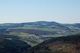
The Scharteberg is a mountain, 691.4 metres (2,268 ft) high,[1] near Kirchweiler in the district of Vulkaneifel and is one of the highest peaks in the Eifel region of Germany. On the summit is the Eifel Transmitter which belongs to SWR and is used for FM radio and television.
| Scharteberg | |
|---|---|
 View of the Scharteberg from the Mäuseberg | |
| Highest point | |
| Elevation | 691.4 m (2,268 ft)[1] |
| Coordinates | 50°13′04″N 6°45′10″E |
| Geography | |
 Scharteberg Rheinland-Pfalz, Germany | |
| Parent range | Eifel |
References
На других языках
[de] Scharteberg
Der Scharteberg ist eine 691,4 m ü. NHN[1] hohe Erhebung bei Kirchweiler im Landkreis Vulkaneifel und somit eine der höchsten Erhebungen der Eifel. Auf ihm befindet sich der Sender Eifel des SWR für UKW-Hörfunk und Fernsehen.- [en] Scharteberg
Текст в блоке "Читать" взят с сайта "Википедия" и доступен по лицензии Creative Commons Attribution-ShareAlike; в отдельных случаях могут действовать дополнительные условия.
Другой контент может иметь иную лицензию. Перед использованием материалов сайта WikiSort.org внимательно изучите правила лицензирования конкретных элементов наполнения сайта.
Другой контент может иметь иную лицензию. Перед использованием материалов сайта WikiSort.org внимательно изучите правила лицензирования конкретных элементов наполнения сайта.
2019-2025
WikiSort.org - проект по пересортировке и дополнению контента Википедии
WikiSort.org - проект по пересортировке и дополнению контента Википедии