geo.wikisort.org - Mountains
The Schafkopf, with its height of 616.8 metres,[1] is one of the few mountains of the Palatine Forest that exceeds the 600 metre mark. It lies south of the Forest's highest peak, the Kalmit, in the Palatine Forest-North Vosges Biosphere Reserve, not far from the municipality of St. Martin and, together with the Morschenberg (608 m), Rotsohlberg (607 m) and Steigerkopf (614 m), forms a contiguous massif. The Schafkopf is entirely forested. There are no official paths or tracks to the actual summit.
| Schafkopf | |
|---|---|
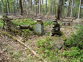
 The summit of the Schafkopf | |
| Highest point | |
| Elevation | 616.8 m above sea level (NN) (2,024 ft)[1] |
| Coordinates | 49°18′47″N 8°02′58″E |
| Geography | |
 Schafkopf Rhineland-Palatinate, | |
| Parent range | Haardt (Palatinate), Palatine Forest |
References
- LANIS. "Topographische Karte". Retrieved 2015-02-27.
На других языках
[de] Schafkopf (Haardt)
Der Schafkopf ist ein 616,8 m ü. NHN[1] hoher Berg im Mittleren Pfälzerwald, einer Teilregion des Pfälzerwaldes. Über den Berg verläuft die Gemarkungsgrenze der Gemeinden Maikammer und Sankt Martin im rheinland-pfälzischen Landkreis Südliche Weinstraße. Er gehört zu den Bergen im Pfälzerwald, deren Höhe die 600-m-Höhenlinie übersteigt.- [en] Schafkopf (Haardt)
Текст в блоке "Читать" взят с сайта "Википедия" и доступен по лицензии Creative Commons Attribution-ShareAlike; в отдельных случаях могут действовать дополнительные условия.
Другой контент может иметь иную лицензию. Перед использованием материалов сайта WikiSort.org внимательно изучите правила лицензирования конкретных элементов наполнения сайта.
Другой контент может иметь иную лицензию. Перед использованием материалов сайта WikiSort.org внимательно изучите правила лицензирования конкретных элементов наполнения сайта.
2019-2025
WikiSort.org - проект по пересортировке и дополнению контента Википедии
WikiSort.org - проект по пересортировке и дополнению контента Википедии