geo.wikisort.org - Mountains
Scafells, also known as the Scafell Massif,[1] range of fells in the western English Lake District, made up of the remains of a caldera volcano. Fells in the range include Scafell, England's tallest mountain Scafell Pike, Broad Crag and Ill Crag. Great End, Lingmell and Slight Side are also usually included within the definition. These hills form part of the Southern Fells.
| Scafells | |
|---|---|
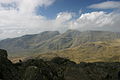
 View of the Scafells from Wastwater | |
| Highest point | |
| Elevation | max. 978 m (3,209 ft) at Scafell Pike |
| Coordinates | 54.471°N 3.144°W |
| Geography | |
 Scafells Cumbria, England  Scafells Scafells (England)  Scafells Scafells (the United Kingdom) | |
| Parent range | Lake District |
| Geology | |
| Age of rock | - |
| Mountain type | Caldera |
| Last eruption | - |

Geology
Geologically, the Scafells are the remnants of a volcano that erupted in the Ordovician period over 400 million years ago. This volcano as well as all other volcanoes of the Lake District are long since extinct.[2]
The volcano is an example of a piecemeal caldera whose collapse, in contrast with a wholesale piston-like subsidence, occurred in a piece-by-piece fashion along faults and whose measurements suggest formation from an eruption of a VEI-7 magnitude.[2] The Scafell Dacite, between Little Narrowcove and Aaron Crags, is a lava dome formed during the last stages of volcanic activity at Scafells.[2]
Gallery
 Scafells from Bowfell

References
- Gannon, Paul (April 2009). Rock Trails Lakeland - A Hillwalker's Guide to the Geology & Scenery. Pesda Press. ISBN 9781906095154. Retrieved 29 April 2021.
- Geology of England and Wales, pp118ff
Другой контент может иметь иную лицензию. Перед использованием материалов сайта WikiSort.org внимательно изучите правила лицензирования конкретных элементов наполнения сайта.
WikiSort.org - проект по пересортировке и дополнению контента Википедии