geo.wikisort.org - Mountains
Savur-Mohyla (Ukrainian: Савур-могила), often transliterated using the Russian spelling Saur-Mogila (Russian: Саур-Могила), is a strategic height in the Donets ridge near the city of Snizhne, located about 5 km (3.1 mi) from the border between Ukraine and Russia's Rostov Oblast.
| Savur-Mohyla Memorial | |
|---|---|
 Savur-Mohyla Memorial, 2008 | |
| For Red Army soldiers fallen during World War II | |
| Unveiled | 1963 |
| Location | near |
| Designed by | Anatoly Ignashchenko |
The 277.9 m (912 ft) tall hill is better known for a big monument complex that was built in 1963 by Ukrainian architect Anatoly Ignashchenko to commemorate the 20th anniversary of the liberation of Savur Mohyla during World War II.
History
It was originally a tumulus (kurgan) – mohyla means "tumulus" in Ukrainian and according to one interpretation the word savur comes from Turkic sauyr, meaning "steppe mound shaped like a horse bottom".[citation needed] Rosamund Bartlett writes, "Many popular legends had been spun about this particular kurgan, which had acted as a kind of frontier between the Russians and the Turks and Tatars in the mediaeval period; Saur appears in them either as an evil Turkish khan or a Cossack hero."[1]
World War II
During World War II, Savur-Mohyla was the focal point of intense fighting, when Soviet troops managed to retake control of the height from German forces in August 1943. In 1963, a memorial complex was unveiled at the top of the hill to honour fallen soldiers,[2] comprising an obelisk with a steel-and-concrete statue of a Soviet soldier, four steel-and-concrete sculptures built along the slope leading up to the obelisk (each memorializing infantrymen, tankmen, artillerymen and airmen involved in the battle), and walls inscrcribed with the names of fallen soldiers in the battle.
2014 war in Donbas
In 2014, during the first months of the military conflict between Ukrainian troops and pro-Russian separatists in the Donbas, the Savur-Mohyla height was captured by pro-Russian fighters. On 23 July 2014, pro-Russian forces shot down two Ukrainian Air Force Sukhoi Su-25 (NATO reporting name "Frogfoot") ground-attack aircraft flying at 17,000 feet (5,182 meters) over Savur-Mohyla, using an advanced anti-aircraft system.[3][4]
On 28 July 2014, after intense fighting, the Armed Forces of Ukraine claimed that they recaptured control of Savur-Mohyla from pro-Russian fighters.[5] However, the commander of the Donetsk People's Republic, Igor Girkin, denied Savur-Mohyla had been lost, saying fighting was continuing.[6] Following its capture by the Ukrainian 25th Airborne Brigade on 9 August 2014,[7] the DPR recaptured the hill on 26 August 2014.[8][9] During the fighting, the hill changed sides between the Ukraine and DPR about 8 times.
Destruction of the memorial
On 21 August 2014, the memorial's obelisk collapsed after enduring weeks of heavy shelling.[8][10]
Reconstruction
On 4 September 2022, representatives of the Donetsk People's Republic announced completion of restoration works on the complex with official reopening to occur on 8 September.
Gallery
 Red Army soldiers near Saur-Mogila during World War 2
 Monument to Soviet infantrymen in World War 2
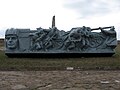 Monument to Soviet tankmen in World War 2
 Monument to Soviet pilots in World War 2
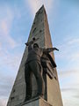 Soviet soldier statue next to the former obelisk
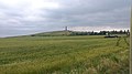 Ukrainian soldiers near the memorial before the Battle of Shakhtarsk Raion in June 2014
 Ukrainian soldiers fire multiple 2S5 Giatsint-S at DPR positions at Saur-Mogila, July 2014
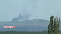 Ukrainian soldiers bombing DPR positions in Saur-Mogila, July 2014
 Ukrainian BM-21 rockets exploding at Saur-Mogila, July 2014
 Large memorial to World War 2 Soviet soldiers in August 2015
 Close-up of the memorial
 Another view of the memorial
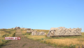 Saur-Mogila in 2015 with notable damage a year after the war in Donbas battle
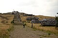 HD view of the path and visitors
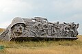 Aftermath of the monument to Soviet infantrymen
 Aftermath of the monument to Soviet tankmen
 Aftermath of the monument to Soviet artillerymen
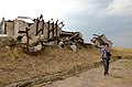 Aftermath of the monument to Soviet pilots
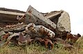 Soviet pilot statue collapsed in front of rubble
 More pilot statues amongst the rubble
 A memorial considerably damaged after the battle
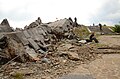 Path to the destroyed obelisk
 Outside view of the former obelisk
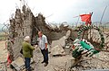 Rubble inside of the former obelisk
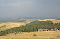 View of the area in front of Saur-Mogila
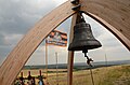 Cemetery for fighters of DPR Vostok Battalion unit called "Medvedevtsi", with an old bell
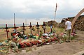 Closeup of fallen DPR fighters that died for the capture of the hill


References
- Rosamund Bartlett, Chekhov: Scenes from a Life (Free Press, 2005), p. 45.
- GPW Veterans Celebrate Victory Day At Savur-Mohyla, UKRINFORM, 9 May 2008
- Two Ukrainian fighter jets shot down as Kiev accuses Moscow of sending more arms to fighters, FoxNews, 23 July 2014.
- Two Ukrainian military jets shot down over rebel-held area, Washington Post, 23 July 2014.
- Ukrainian Armed Forces take control of Saur-Mohyla - report to president, Interfax, 28 July 2014.
- "Ukraine claims more territory as fight intensifies with rebels". Reuters. 28 July 2014. Retrieved 28 July 2014.
- Ополчение отступило со стратегической высоты Саур-Могила // RIA Novosti, 9 August 2014
- Panoramic video of the destroyed memorial, Lifenews.ru, August 28, 2014
- Donetsk militia claims assuming control of border stretch to Azov Sea, ITAR-TASS, 26 August 2014
- Savur-Mohyla Left Without Obelisk Because of Shelling, Censor.NET, August 21, 2014
War in Donbas (2014–2022) | |||||
|---|---|---|---|---|---|
Part of the Russo-Ukrainian War | |||||
| General topics |
| ||||
| Timeline |
| ||||
| Battles |
| ||||
| Other events |
| ||||
| Self-proclaimed states |
| ||||
| (Pro-) Russian |
| ||||
| Ukrainian |
| ||||
| Authority control |
|
|---|
На других языках
[de] Anhöhe von Sawur-Mohyla
47.92298611111138.740538888889- [en] Savur-Mohyla
Другой контент может иметь иную лицензию. Перед использованием материалов сайта WikiSort.org внимательно изучите правила лицензирования конкретных элементов наполнения сайта.
WikiSort.org - проект по пересортировке и дополнению контента Википедии