geo.wikisort.org - Mountains
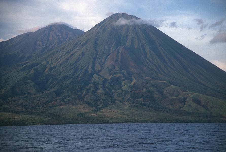
Sangeang Api (Gunung Api or Gunung Sangeang) is an active complex volcano on the island of Sangeang in Indonesia. It consists of two volcanic cones, 1,949 metres (6,394 ft) Doro Api and 1,795 m (5,889 ft) Doro Mantoi.[1] Sangeang Api is one of the most active volcanoes in the Lesser Sunda Islands. It erupted in 1988 and the island's inhabitants were evacuated. Between its first recorded eruption in 1512 and 1989 it erupted 17 times. It erupted again during December 2012 and May 2014.[3][4]
| Sangeang Api | |
|---|---|
 | |
| Highest point | |
| Elevation | 1,949 m (6,394 ft)[1] |
| Prominence | 1,949 m (6,394 ft)[2] |
| Listing | Ultra Ribu List of volcanoes in Indonesia |
| Coordinates | 8°11′48″S 119°04′12″E[2] |
| Geography | |
 Sangeang Api Indonesia | |
| Location | Lesser Sunda Islands, Indonesia |
| Geology | |
| Mountain type | Complex volcano |
| Last eruption | 2020[1] |
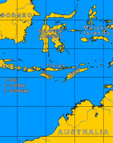
The island of Sangeang is part of the Lesser Sunda Islands. It is located northeast of Sumbawa in the Flores Sea, and is 13 km wide with an area of 153 km2.[5]
The earliest document mentioning about the Sang Hyang Api volcano was found in 14th century Majapahit script of Nagarakretagama. "Gunung Api" also appears as the name for the mountain in the first chapter of the novel The Long Journey by Johannes V. Jensen.
2014 Eruption
Since mid-June 2013, authorities had put the volcano on 'high alert' for a possible eruption. On May 30, 2014, a major eruption occurred at around 3:55 p.m. local time. Farmers working on the island were evacuated. Ash and smoke quickly rose to an altitude 15–20 km (≈10–16 miles) into the sky.[4] By the next morning, the ash cloud had crossed the north-west coast of Australia in the Kimberley region, and airlines had cancelled flights into and from Darwin, Northern Territory. It later went as far as Alice Springs in the Northern Territory.[6] On 31 May some flights from Melbourne and Adelaide to Bali were also cancelled.[6]
Climate
Sangeang Api has a subtropical highland climate (Cfb). It has moderate rainfall from June to September and heavy to extremely heavy rainfall in the remaining months.
| Climate data for Sangeang Api summit | |||||||||||||
|---|---|---|---|---|---|---|---|---|---|---|---|---|---|
| Month | Jan | Feb | Mar | Apr | May | Jun | Jul | Aug | Sep | Oct | Nov | Dec | Year |
| Average high °C (°F) | 21.8 (71.2) |
21.4 (70.5) |
22.2 (72.0) |
22.2 (72.0) |
21.8 (71.2) |
21.1 (70.0) |
21.0 (69.8) |
21.9 (71.4) |
22.7 (72.9) |
23.2 (73.8) |
22.2 (72.0) |
21.5 (70.7) |
21.9 (71.5) |
| Daily mean °C (°F) | 17.2 (63.0) |
16.9 (62.4) |
17.5 (63.5) |
17.2 (63.0) |
16.8 (62.2) |
16.1 (61.0) |
15.5 (59.9) |
16.0 (60.8) |
16.7 (62.1) |
17.5 (63.5) |
17.5 (63.5) |
17.1 (62.8) |
16.8 (62.3) |
| Average low °C (°F) | 12.6 (54.7) |
12.4 (54.3) |
12.8 (55.0) |
12.3 (54.1) |
11.9 (53.4) |
11.1 (52.0) |
10.1 (50.2) |
10.1 (50.2) |
10.7 (51.3) |
11.8 (53.2) |
12.8 (55.0) |
12.7 (54.9) |
11.8 (53.2) |
| Average precipitation mm (inches) | 776 (30.6) |
633 (24.9) |
571 (22.5) |
350 (13.8) |
193 (7.6) |
94 (3.7) |
64 (2.5) |
62 (2.4) |
95 (3.7) |
165 (6.5) |
365 (14.4) |
553 (21.8) |
3,921 (154.4) |
| Source: Climate-Data.org[7] | |||||||||||||
References
- "Sangeang Api". Global Volcanism Program. Smithsonian Institution.
- "Mountains of the Indonesian Archipelago". Peaklist.org. Retrieved 2015-04-11.
- Smithsonian Institution / SEAN (1989). Lindsay McClelland; Tom Simkin; Marjorie Summers; Elizabeth Nielsen; Thomas C Stein (eds.). Global Volcanism 1975-1985. Prentice Hall, Englewood Cliffs NJ, and American Geophysical Union, Washington DC. pp. 217–219. ISBN 0-13-357203-X.
- "Volcano Mount Sangiang Api erupts in Indonesia, farmers evacuated". IANS. news.biharprabha.com. 30 May 2014. Retrieved 30 May 2014.
- Monk, K.A.; Fretes, Y.; Reksodiharjo-Lilley, G. (1996). The Ecology of Nusa Tenggara and Maluku. Hong Kong: Periplus Editions Ltd. p. 7. ISBN 962-593-076-0.
- "Ash grounds flights to Darwin, Bali". www.sbs.com.au. Retrieved 1 June 2014.
- "Climate: Sangeang". Climate-Data.org. Retrieved July 9, 2020.
External links
- NASA Space Shuttle images:
- STS112-E-5628 Directly from above volcano.
- STS61A-40-62
На других языках
- [en] Sangeang Api
[fr] Sangeang Api
Le Sangeang Api est un volcan et le point culminant de l'île indonésienne de Sangeang.[ru] Апи (вулкан, остров Сангеанг)
Апи[2] (индон. Sangeang Api) — вулкан на острове Сангеанг, Индонезия. Вулканическая система имеет два конуса — Апи (1949 м) и Мантои (1795 м). Последнее извержение было в 2014 году. Фиксируется сильная фумарольная активность.Другой контент может иметь иную лицензию. Перед использованием материалов сайта WikiSort.org внимательно изучите правила лицензирования конкретных элементов наполнения сайта.
WikiSort.org - проект по пересортировке и дополнению контента Википедии