geo.wikisort.org - Mountains
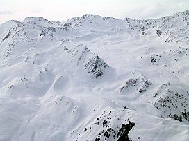
The Roter Kogel is a mountain, 2,832 m (AA), in the Stubai Alps in the Austrian state of Tyrol.
| Roter Kogel | |
|---|---|
 | |
| Highest point | |
| Elevation | 2,832 m (9,291 ft) |
| Isolation | 0.63 km (0.39 mi) |
| Coordinates | 47°08′00″N 11°10′0″E |
| Geography | |
| Location | Tyrol, Austria |
| Parent range | Stubai Alps |
It lies on a ridge that runs from the Hohe Villerspitze over the Lüsener Villerspitze (3,027 m (AA)) northwards as far as the Fotscher Windegg (2,577 m (AA)). West of this chain lies the Lüsener Valley and the village of Praxmar, a starting point for an ascent of the Roter Kogel. East of the Roter Kogels stretches the valley of Fotscher Tal, where there are two other bases: the Alpengasthof Bergheim Fotsch (1,464 m (AA)) and the Potsdamer Hut. This ascent up the eastern side is also a popular ski tour in winter.
Literature
- Heinrich und Walter Klier, Alpenvereinsführer Stubaier Alpen, Bergverlag Rudolf Rother, München 1988. ISBN 3-7633-1252-8
На других языках
[de] Roter Kogel
Der Rote Kogel ist ein 2832 m ü. A. hoher Berg in den Stubaier Alpen in Tirol.- [en] Roter Kogel
[fr] Roter Kogel
Le Roter Kogel est une montagne qui s’élève à 2 832 m d’altitude dans les Alpes de Stubai, en Autriche.Текст в блоке "Читать" взят с сайта "Википедия" и доступен по лицензии Creative Commons Attribution-ShareAlike; в отдельных случаях могут действовать дополнительные условия.
Другой контент может иметь иную лицензию. Перед использованием материалов сайта WikiSort.org внимательно изучите правила лицензирования конкретных элементов наполнения сайта.
Другой контент может иметь иную лицензию. Перед использованием материалов сайта WikiSort.org внимательно изучите правила лицензирования конкретных элементов наполнения сайта.
2019-2025
WikiSort.org - проект по пересортировке и дополнению контента Википедии
WikiSort.org - проект по пересортировке и дополнению контента Википедии