geo.wikisort.org - Mountains
The Rosenstein is a 735 m high mountain in the Swabian Jura (German: Schwäbische Alb) above the town of Heubach near Schwäbisch Gmünd, Germany.
| Rosenstein | |
|---|---|
 Rosenstein Mountain | |
| Highest point | |
| Elevation | 735 m (2,411 ft) |
| Coordinates | 48°47′47″N 9°57′37″E |
| Geography | |
 Rosenstein The location within Baden-Württemberg | |
| Location | Baden-Wuerttemberg, Germany |
| Parent range | Swabian Jura |
With its exposed position as head of the Alb it had been of strategic importance. Excavations in the caves on Rosenstein have found tools dating back to the Paleolithic period. Among the best-known caves are scouring the "Great" and "Dark hole". About the Western rock, the remnants of a medieval castle, Rosenstein castle ruins.
The Rosenstein is now a very popular recreational area, especially for climbers and mountain bikers.
 Rosenstein Ruins
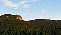 Rosenstein Ruins and Telecommunication Tower
 Rosenstein Ruins above Heubach


See also
- Petrosomatoglyph
External links
Authority control | |
|---|---|
| General |
|
| National libraries | |
На других языках
[de] Rosenstein (Berg)
Der Rosenstein ist ein 735,4 m ü. NHN[1] hoher Berg der Schwäbischen Alb oberhalb von Heubach im Ostalbkreis in Baden-Württemberg.- [en] Rosenstein (Swabian Jura)
Текст в блоке "Читать" взят с сайта "Википедия" и доступен по лицензии Creative Commons Attribution-ShareAlike; в отдельных случаях могут действовать дополнительные условия.
Другой контент может иметь иную лицензию. Перед использованием материалов сайта WikiSort.org внимательно изучите правила лицензирования конкретных элементов наполнения сайта.
Другой контент может иметь иную лицензию. Перед использованием материалов сайта WikiSort.org внимательно изучите правила лицензирования конкретных элементов наполнения сайта.
2019-2025
WikiSort.org - проект по пересортировке и дополнению контента Википедии
WikiSort.org - проект по пересортировке и дополнению контента Википедии