geo.wikisort.org - Mountains
Rose Knob Peak is a 9,710-foot-elevation mountain summit located in Washoe County, Nevada, United States.
| Rose Knob Peak | |
|---|---|
 South aspect, centered at top | |
| Highest point | |
| Elevation | 9,710 ft (2,960 m)[1][2] |
| Prominence | 270 ft (82 m)[3] |
| Parent peak | Relay Peak (10,338 ft)[4] |
| Isolation | 1.61 mi (2.59 km)[4] |
| Coordinates | 39°17′37″N 119°57′28″W[5] |
| Geography | |
 Rose Knob Peak Location in Nevada  Rose Knob Peak Rose Knob Peak (the United States) | |
| Location | Mount Rose Wilderness |
| Country | United States of America |
| State | Nevada |
| County | Washoe |
| Parent range | Sierra Nevada Carson Range |
| Topo map | USGS Mount Rose |
| Climbing | |
| Easiest route | class 2[6] |
Description
Rose Knob Peak is set four miles north of Lake Tahoe in the Mount Rose Wilderness, on land managed by the Humboldt-Toiyabe National Forest. It is part of the Carson Range which is a subset of the Sierra Nevada. It is situated 1.6 miles (2.6 km) south-southwest of line parent Relay Peak and three miles (4.8 km) north of Incline Village. Topographic relief is significant as the summit rises 2,500 feet (762 meters) above Third Creek in 1.5 mile. The Tahoe Rim Trail traverses the slope of the peak, providing an approach option. This landform's toponym has been officially adopted by the U.S. Board on Geographic Names.[5]
Climate
According to the Köppen climate classification system, Rose Knob Peak is located in an alpine climate zone.[7] Most weather fronts originate in the Pacific Ocean, and travel east toward the Sierra Nevada mountains. As fronts approach, they are forced upward by the peaks (orographic lift), causing them to drop their moisture in the form of rain or snowfall onto the range. Most of the snow in Nevada falls from December through March.[8]
See also
- List of Lake Tahoe peaks
 Mountains portal
Gallery
 Northeast aspect
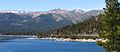 South aspect centered, from Lake Tahoe


References
- United States Geological Survey topographical map - Mount Rose
- Tim Hauserman (2012), Tahoe Rim Trail, Wilderness Press, ISBN 9780899977119, p. 90
- "Rose Knob Peak, Nevada". Peakbagger.com. Retrieved 2022-07-26.
- "Rose Knob Peak - 9,704' NV". listsofjohn.com. Retrieved 2022-07-26.
- "Rose Knob Peak". Geographic Names Information System. United States Geological Survey, United States Department of the Interior. Retrieved 2022-07-26.
- Rose Knob Peak, Tahoeogul.org
- "Climate of the Sierra Nevada". Encyclopædia Britannica.
- John G. Houghton (1975), Nevada's Weather and Climate, Nevada Bureau of Mines and Geology, University of Nevada, p. 53
External links
- Weather forecast: Rose Knob Peak
- Rose Knob Peak: Tahoeogul.org
Другой контент может иметь иную лицензию. Перед использованием материалов сайта WikiSort.org внимательно изучите правила лицензирования конкретных элементов наполнения сайта.
WikiSort.org - проект по пересортировке и дополнению контента Википедии