geo.wikisort.org - Mountains
The Rocher de la Tournette (or, simply, 'La Tournette'[1]) is a prominent rocky point on the icy summit ridge of Mont Blanc between the Petite Bosse and the summit. The highest point lies at 4,677 metres (15,344 ft) above sea level, and can be most easily reached on an ascent of Mont Blanc via the Goûter Route.
| Rocher de la Tournette | |
|---|---|
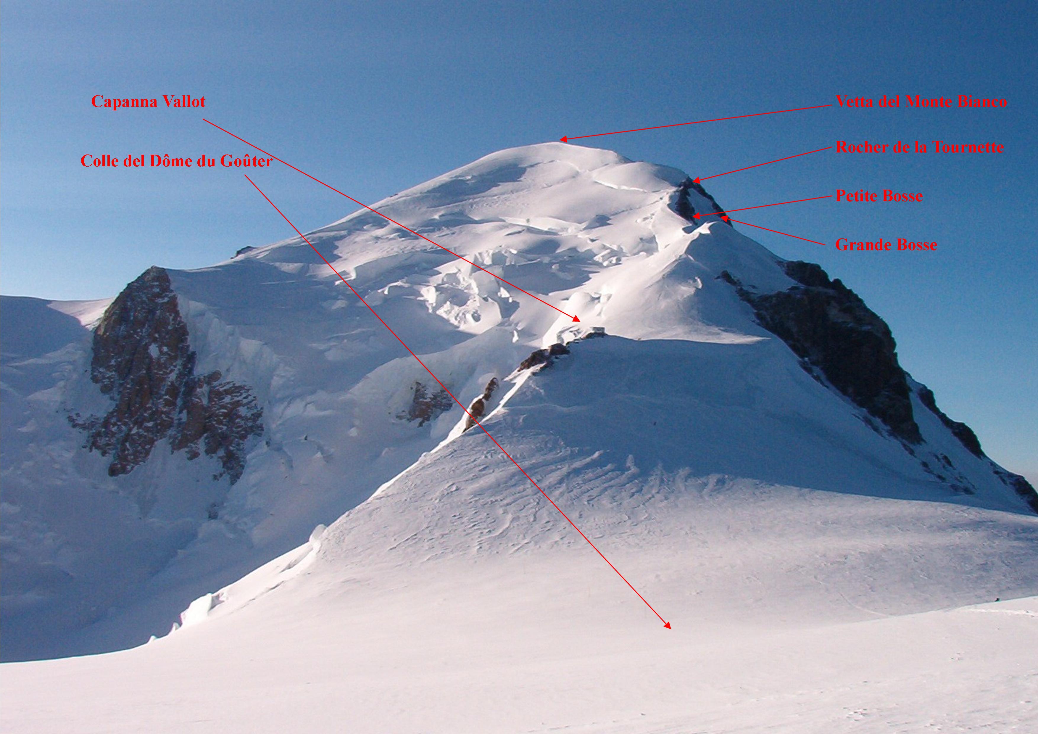 Mont Blanc with Rocher de la Tournette shown on right hand skyline, below summit. | |
| Highest point | |
| Elevation | 4,677 m (15,344 ft) |
| Coordinates | 45°49′58″N 6°51′34″E |
| Naming | |
| Language of name | French / Italian |
| Geography | |
 Location on border with Italy and France | |
| Location | Aosta Valley, Italy / Haute-Savoie, France |
| Parent range | Mont Blanc Massif |
| Climbing | |
| Easiest route | Goûter Route |
Whilst not sufficiently isolated from other summits to be regarded by the UIAA as one of the 82 primary 4000 metre summits of the Alps, the organisation does nevertheless include Rocher de la Tournette on its 'Enlarged list of lesser summits'. This list defines a further 46 such points of secondary mountaineering or morphological interest, of which the Rocher de la Tournette is the highest.[2]
The shoulder of this rocky subsidiary summit offers a remote mountaineering route from the Quintino Sella Hut. Known as the Tournette Spur (fr: l’éperon de la Tournette), it enables the final 'Bosses Ridge' section of the Goûter Route to be reached from the Italian side of Mont Blanc.[3] This infrequently climbed route is nowadays graded AD on the adjectival climbing scale and was first climbed on 2 July 1872 by T Kennedy, J Carrel and J Fischer. The first winter ascent of the Tournette Spur was made by the three Sella brothers and their guides, including Emile Rey on 5 January 1888.[4]: 58 [5][6]
Air crash site
The Lockheed Constellation Malabar Princess (Air India Flight 245) crashed near the Rocher de la Tournette on November 3, 1950, killing all 48 passengers and crew members,[7] a tragedy which inspired the 1952 novel La Neige en deuil (The Snow in mourning) of Henri Troyat (adapted to the cinema in 1956), as well as the movie Malabar Princess in 2004.
A second accident occurred on 24 January 1966, involving Air India Flight 101, a Boeing 707 which struck the outcrop in the same sector, resulting in the deaths of all 117 passengers and crew members.[8] In 2013, this crash inspired a novel by Marc Levy, Un sentiment plus fort que la peur (A feeling stronger than fear, English translation 2013, also under the title Stronger than Fear).
See also
References
- Baud, Anselme (2015-03-04). Mont Blanc and the Aiguilles Rouges - a Guide for Skiers: Complete Guide: Travel Guide. Primento. p. 311. ISBN 9782511031186.
- "The 4000ers of the Alps - Official UIAA List" (PDF). www.club4000.it. International Climbing and Mountaineering Federation. March 1994. Retrieved 1 January 2019.
- "Mont Blanc Guide :: Edmond Joyeusaz :: E-Joy Experience". www.montblancguide.it. Retrieved 2019-01-05.
- Griffin, Lindsay (1990). Mont Blanc Massif Volume 1. London: Alpine Club. ISBN 0900523573.
- "Tournette Spur : Climbing, Hiking & Mountaineering : SummitPost". www.summitpost.org. Retrieved 2019-01-02.
- "Mont Blanc : Tournette spur". camptocamp.org. Retrieved 2019-01-02.
- "The "Malabar Princess" Catastrophe". Archived from the original on 20 June 2009. Retrieved 17 June 2009.
- Accident description at the Aviation Safety Network
На других языках
- [en] Rocher de la Tournette
[fr] Rocher de la Tournette
Le rocher de la Tournette est un épaulement rocheux, à 4 677 mètres d'altitude, sur la voie normale du mont Blanc (l’arête des Bosses) entre la Petite Bosse et le sommet. Il n'est pas considéré comme un des 82 sommets des Alpes de plus de 4 000 mètres, mais apparaît dans la liste complémentaire des sommets secondaires. Il est également le sommet de l’éperon de la Tournette (AD), qui permet d'atteindre le sommet du mont Blanc depuis le refuge Quintino Sella.[it] Rocher de la Tournette
Il Rocher de la Tournette (4.677 m s.l.m.) è una spalla rocciosa del Monte Bianco. Si trova lungo la via normale di salita al Monte Bianco.Другой контент может иметь иную лицензию. Перед использованием материалов сайта WikiSort.org внимательно изучите правила лицензирования конкретных элементов наполнения сайта.
WikiSort.org - проект по пересортировке и дополнению контента Википедии