geo.wikisort.org - Mountains
Rima Rima (Quechua rima speaking, rima rima a flower (Ranunculus weberbaueri syn. Krapfia weberbaueri)),[2][3] is a 5,248-metre-high (17,218 ft) mountain in the Cordillera Blanca in the Andes of Peru. It is situated in the Ancash Region, Huaraz Province, Independencia District, northeast of Huaraz (Waras). Rima Rima lies southeast of Wallunarahu, on the ridge southwest of Ranrapallqa.
 Ranrapallqa (in the distance), Rima Rima, Churup (middle, left), Qullapaqu and Wamashrahu as seen from Huaraz

| Rima Rima | |
|---|---|
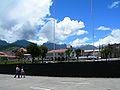
 Wallunarahu and Ranrapallqa (both snow-covered), Rima Rima and Churup (on the right) as seen from Huaraz | |
| Highest point | |
| Elevation | 5,248 m (17,218 ft)[1] |
| Coordinates | 9°26′48″S 77°26′18″W |
| Geography | |
 Rima Rima Peru | |
| Location | Peru, Ancash Region |
| Parent range | Andes, Cordillera Blanca |
See also
- Churup
- Wamashrahu
References
- "Cerro Rima Rima". IGN, Peru. Retrieved April 9, 2015.
- Teofilo Laime Ajacopa (2007). Diccionario Bilingüe Iskay simipi yuyayk’anch [Quechua-English dictionary] (PDF). La Paz, Bolivia.
- Blanca León, Ranunculaceae endémicas del Perú, Rev. peru. biol. Número especial 13(2): 580s - 581s (Diciembre 2006), El libro rojo de las plantas endémicas del Perú. Ed.: Blanca León et al., Facultad de Ciencias Biológicas UNMSM
This Ancash Region geography article is a stub. You can help Wikipedia by expanding it. |
Текст в блоке "Читать" взят с сайта "Википедия" и доступен по лицензии Creative Commons Attribution-ShareAlike; в отдельных случаях могут действовать дополнительные условия.
Другой контент может иметь иную лицензию. Перед использованием материалов сайта WikiSort.org внимательно изучите правила лицензирования конкретных элементов наполнения сайта.
Другой контент может иметь иную лицензию. Перед использованием материалов сайта WikiSort.org внимательно изучите правила лицензирования конкретных элементов наполнения сайта.
2019-2026
WikiSort.org - проект по пересортировке и дополнению контента Википедии
WikiSort.org - проект по пересортировке и дополнению контента Википедии