geo.wikisort.org - Mountains
Rano Kau is a 324 m (1,063 ft) tall dormant volcano that forms the southwestern headland of Easter Island, a Chilean island in the Pacific Ocean. It was formed of basaltic lava flows in the Pleistocene with its youngest rocks dated at between 150,000 and 210,000 years ago.

The crater
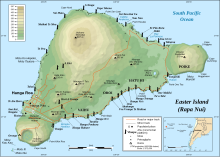
Rano Kau has a crater lake which is one of the island's only three natural bodies of fresh water. The lake is located approximately 100 metres (330 ft) above sea level, but is more than 200 metres (660 ft) below the highest of the crater's ridges. The volcanic cone is largely surrounded by water, and much of it has been eroded back to form high sea cliffs which at one point (te kari kari) have started to bite into the crater wall. The inside walls of the crater are sloped at an angle of between 65° (steepest, near the crest) and 45° (gentlest, at the lake shore). From the ruins of the ceremonial village of Orongo the cliff face drops to the southwest at an angle of 50° to the sea shore some 300 metres (980 ft) below. On its northern side, the volcano slopes down to Mataveri International Airport.
Rano Kau is in the World Heritage Site of Rapa Nui National Park and gives its name to one of the seven sections of the park. The principal archaeological site on Rano Kau is the ruined ceremonial village of Orongo which is located at the point where the sea cliff and inner crater wall converge. One ahu with several moai was recorded on the cliffs at Rano Kau in the 1880s, but had fallen to the beach by the time of the Routledge expedition in 1914.
As well as basalt, it contains several other igneous rocks including obsidian (for which it was one of the major sources for the island's stoneworkers) and pumice.
The crater is almost a mile across and has its own micro climate. Sheltered from the winds that wet most of the rest of the island, figs and vines flourish at Rano Kau.[1] The inner slope was the site of the last toromiro tree in the wild until the specimen was chopped down for firewood in 1960.

Geothermal activity
At some point in the early twentieth century, the island's manager took a photograph of steam coming out of the crater wall.[2]
See also
- List of volcanoes in Chile
- Sirolimus
References
- Flenley & Bahn 2003 The enigmas of Easter Island ISBN 0-19-280340-9 page 18
- Steam crack in Rano Kau
- Haase, Karsten M.; Peter Stoffers; C. Dieter Garbe-Schönberg (October 1997). "The Petrogenetic Evolution of Lavas from Easter Island and Neighbouring Seamounts, Near-ridge Hotspot Volcanoes in the SE Pacific". Journal of Petrology. 38 (6): 785–813. doi:10.1093/petrology/38.6.785.
- Katherine Routledge, 1919. The Mystery of Easter Island. ISBN 0-932813-48-8
- Van Tilburg, Jo Anne. 1994. Easter Island: Archaeology, Ecology and Culture. Washington D.C.: Smithsonian Institution Press. [ISBN missing]
External links
World Heritage Sites in Chile | ||
|---|---|---|
| ||
На других языках
[de] Rano Kao
Der Rano Kao ist ein bis zu 320 m hoher, erloschener Schildvulkan im Südwesten der Osterinsel, dessen Gestein auf ein Alter von etwa 1 Million Jahren datiert wurde.[1] Der 200 m tiefe Gipfelkrater ist eine durch den Einsturz des Vulkangipfels entstandene Caldera. Er ist mit einem Durchmesser von 1,6 km der größte Vulkankrater auf der Osterinsel. Der Rand des Kraters ist nach Südwesten zum Meer hin leicht eingebrochen. Die drei der Küste vorgelagerten Motus – Motu Kaokao, Motu Iti und Motu Nui – sind wahrscheinlich die Reste parasitärer Vulkane des Rano Kao.[2]- [en] Rano Kau
[es] Rano Kau
Rano Kau es un volcán ubicado en el extremo suroeste de Rapa Nui, el cual forma uno de los tres grandes conos que forman parte de la superficie de la isla. Tiene una altura de 324 msnm y de acuerdo con estimaciones geológicas su origen se remonta a un proceso eruptivo ocurrido hace unos 2,5 millones de años.[fr] Rano Kau
Le Rano Kau est un volcan du Chili situé à la pointe Sud-Ouest de l'île de Pâques. Il est composé d'un cratère au fond plat recouvert de nombreux petits lacs et abrite le site pascuan d'Orongo au sommet des falaises.[ru] Рано-Кау
Рано-Кау — потухший щитовидный вулкан на острове Пасхи, Чили. Его форма — пологий щит с большим кратером, имеющим 7 озёр. Юго-западный склон разрушен, образуя мыс южный. По склонам идут многочисленные шоссе. Ближайшее поселение — Матавери.Другой контент может иметь иную лицензию. Перед использованием материалов сайта WikiSort.org внимательно изучите правила лицензирования конкретных элементов наполнения сайта.
WikiSort.org - проект по пересортировке и дополнению контента Википедии