geo.wikisort.org - Mountains
The Ramberg, also called the Ramberg Massif, is a granite massif, about 30 square kilometres in area, in the eastern part of the Harz Mountains of central Germany. It is located in the federal state of Saxony-Anhalt and lies southwest of Quedlinburg, between Friedrichsbrunn, Gernrode, Harzgerode and Thale. The Ramberg massif has a number of summits, the highest of which is the Viktorshöhe at 582 m above sea level (NN).
| Ramberg | |
|---|---|
 Ramberg Saxony-Anhalt, Germany | |
| Highest point | |
| Elevation | 582 m (1,909 ft) |
| Coordinates | 51°41′09″N 11°04′57″E |
| Geography | |
| Location | Saxony-Anhalt, Germany |
| Parent range | Harz Mountains |
| Geology | |
| Mountain type | Granite |
Places of interest
In the vicinity of the Viktorshöhe are the two natural monuments, the Kleine Teufelsmühle and Große Teufelsmühle, two granite tors that are shrouded in legend. Also within the Ramberg are the Bremer Teich, the Bear Monument and the castles ruins of Erichsberg.
 The Große Teufelsmühle tor
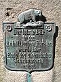 The Bear Monument


External links
- Further information on the Ramberg at Harzlife
- Geology of the Ramberg at the Clausthal University of Technology
На других языках
[de] Ramberg (Harz)
Der Ramberg, auch das Rambergsmassiv genannt, ist ein maximal 587,1 m ü. NHN[2] hohes und etwa 30 km² großes Granitmassiv des Mittelgebirges Harz im sachsen-anhaltischen Landkreis Harz.- [en] Ramberg (Harz)
Текст в блоке "Читать" взят с сайта "Википедия" и доступен по лицензии Creative Commons Attribution-ShareAlike; в отдельных случаях могут действовать дополнительные условия.
Другой контент может иметь иную лицензию. Перед использованием материалов сайта WikiSort.org внимательно изучите правила лицензирования конкретных элементов наполнения сайта.
Другой контент может иметь иную лицензию. Перед использованием материалов сайта WikiSort.org внимательно изучите правила лицензирования конкретных элементов наполнения сайта.
2019-2026
WikiSort.org - проект по пересортировке и дополнению контента Википедии
WikiSort.org - проект по пересортировке и дополнению контента Википедии