geo.wikisort.org - Mountains
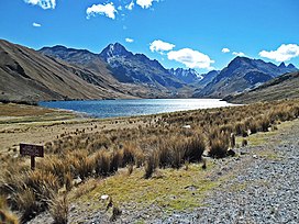
Pucaraju[1][2] (possibly from Quechua puka red,[3] rahu snow, ice, mountain with snow,[4] "red snow-covered mountain") is a mountain in the Cordillera Blanca in the Andes of Peru, about 5,346 metres (17,539 ft) high[1] or 5,322 metres (17,461 ft) high[2] depending on the source. It is situated in the Ancash Region, Recuay Province, Ticapampa District.[5] Pucaraju lies west of Yanamarey and northeast of Lake Querococha.[2]
| Pucaraju | |
|---|---|
| Tunsho, Pucarajo | |
 Lake Querococha and Mount Pucaraju (center-left) | |
| Highest point | |
| Elevation | 5,346 m (17,539 ft) |
| Coordinates | 9°40′30″S 77°18′35″W |
| Geography | |
 Pucaraju Peru | |
| Location | Ancash, Peru |
| Parent range | Cordillera Blanca |
| Climbing | |
| First ascent | 1-1967 via S.face: N.W. ridge-1973.[1] |
The IGN-Peru map, cites the main peak as Tunsho, while applying the name Pucarajo to the southern slopes.[6]
Sources
- Jill Neate, Mountaineering in the Andes, RGS-IBG Expedition Advisory Centre, 2nd edition, May 1994: "Yanamarey Group: Pucaraju 5346m: 1-1967 via S.face: N.W. ridge-1973."
- Alpenvereinskarte 0/3b. Cordillera Blanca Süd (Peru). 1:100 000. Oesterreichischer Alpenverein. 2005. ISBN 3-937530-05-3.
- Teofilo Laime Ajacopa (2007). Diccionario Bilingüe Iskay simipi yuyayk’anch [Quechua-English dictionary] (PDF). La Paz, Bolivia.
- "babylon.com". Archived from the original on 2014-12-29. Retrieved 2013-06-17.
- escale.minedu.gob.pe - UGEL map of the Yungas Province (Ancash Region) showing the location of Pucarahu (unnamed) northeast of the mountain labelled "Cerro Pucaraju" and northeast of the lake Qiruqucha
- Peru 1:100 000, Recuay (20-i). IGN (Instituto Geográfico Nacional - Perú).
Текст в блоке "Читать" взят с сайта "Википедия" и доступен по лицензии Creative Commons Attribution-ShareAlike; в отдельных случаях могут действовать дополнительные условия.
Другой контент может иметь иную лицензию. Перед использованием материалов сайта WikiSort.org внимательно изучите правила лицензирования конкретных элементов наполнения сайта.
Другой контент может иметь иную лицензию. Перед использованием материалов сайта WikiSort.org внимательно изучите правила лицензирования конкретных элементов наполнения сайта.
2019-2025
WikiSort.org - проект по пересортировке и дополнению контента Википедии
WikiSort.org - проект по пересортировке и дополнению контента Википедии