geo.wikisort.org - Mountains
Pucajirca[2][3] or Pucahirca[3] (possibly from Quechua puka red, Ancash Quechua hirka mountain,[4] "red mountain") is a mountain in the Cordillera Blanca in the Andes of Peru, about 6,046 m (19,836 ft) high.[2][3] It is located in the Ancash Region, Pomabamba Province, Pomabamba District (Pucajirca Norte) as well as in the Huaylas Province, Yuracmarca District (Pucajirca Central)[5] north of Rinrijirca.[2] Its slopes are within Huascarán National Park.[6]
| Pucajirca | |
|---|---|
 Pucajirca Oeste (on the left), Rinrijirca (middle-left) and Curuicashajana (on the right) behind the Arhuay Glacier and Arhuaycocha | |
| Highest point | |
| Elevation | 6,046 m (19,836 ft)[1] |
| Prominence | 2,793 m (9,163 ft) |
| Parent peak | Santa Cruz (mountain) |
| Coordinates | 8°50′59″S 77°35′43″W |
| Geography | |
 Pucajirca Peru | |
| Location | Peru, Ancash Region |
| Parent range | Andes, Cordillera Blanca |
| Climbing | |
| First ascent | Pucajirca Oeste: 1930s, Erwin Schneider. Pucajirca Norte: July 14, 1955, Nick Clinch and Andrew Kauffman; July 16, 1955, Harvey McMannis and David Sowles. |
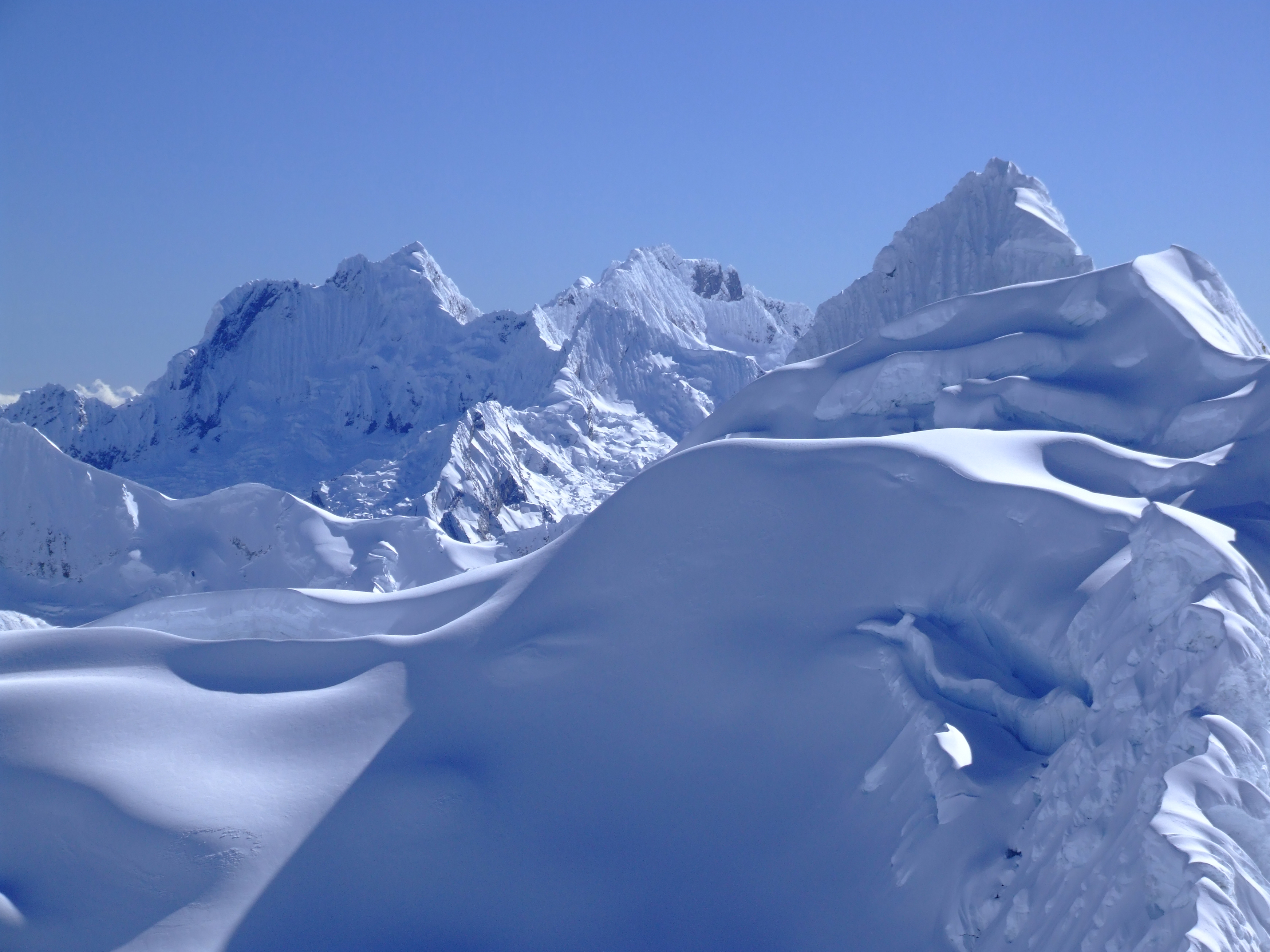
The mountain has three separate and independent summits: Pucajirca Norte (6,046 m), Central (6,014 m) and Oeste (6,039 m).[2] The current DEM data has no enough evidence to confirm its official altitude.[7]
First Ascent
The summit of Pucajirca Norte was first achieved on July 14, 1955, by Nick Clinch and Andrew Kauffman II (USA), also two days later by Harvey McMannis and David Sowles (USA).[8][9][10] Erwin Schneider summited Pucajirca Oeste in the 1930s.[10]
See also
- Arhuaycocha
- Pucacocha
- Taullicocha
- Taulliraju
References
- "Pucajirca". Andes Specialists. Retrieved 2020-04-12.
- Alpenvereinskarte 0/3a. Cordillera Blanca Nord (Peru). 1:100 000. Oesterreichischer Alpenverein. 2005. ISBN 3-928777-57-2.
- Biggar, John (2020). The Andes: A Guide for Climbers and Skiers. Andes. p. 78. ISBN 9780953608768.
- "Vocabulario comparativo, quechua ecuatoriano - quechua ancashino - castellano - English, Brighton 2006" (PDF). Robert Beér, Armando Muyolemaj, Dr. Hernán S. Aguilarpaj. Retrieved October 2, 2015.
- escale.minedu.gob.pe - Map of the Huaylas Province
- PERU, Autor: GEO GPS. "Base de datos Perú - Shapefile - *.shp - MINAM - IGN - Límites Políticos". Retrieved 2020-04-30.
- "Pucajirca". Andes Specialists. Retrieved 2020-04-12.
- "AAJ". AAJ. 1956.
- Harvey N. Platts. Nevado Pucahirca.
- "Nevado Pucahirca - AAC Publications - Search The American Alpine Journal and Accidents". publications.americanalpineclub.org. Retrieved 2018-07-20.
This Ancash Region geography article is a stub. You can help Wikipedia by expanding it. |
На других языках
- [en] Pucajirca
[fr] Pucajirca
Le Pucajirca[1] ou Pucahirca[2] (du quechua puka « rouge », et hirka « montagne »[3], littéralement « montagne rouge ») est une montagne de la cordillère Blanche dans les Andes péruviennes. Elle s'élève à une altitude de 6 046 m. Le Pucajirca est situé dans la région d'Ancash, à la frontière entre la province de Pomabamba et la province de Huaylas, au nord du Rinrijirca (5 810 m).[it] Pucajirca
Con il nome di Pucajirca (quechua Pukahirka) o, più correttamente, con quello plurale di Pucajircas, si indica un gruppo di montagne della Cordillera Blanca, in Perù, nel dipartimento di Ancash. Quattro di queste montagne superano i 6.000 m.Другой контент может иметь иную лицензию. Перед использованием материалов сайта WikiSort.org внимательно изучите правила лицензирования конкретных элементов наполнения сайта.
WikiSort.org - проект по пересортировке и дополнению контента Википедии