geo.wikisort.org - Mountains
Praděd (Czech pronunciation: [ˈpraɟɛt]; German: Altvater; Polish: Pradziad; literally "great grandfather") (1,490.8 metres (4,891 ft)) is the highest mountain of the Hrubý Jeseník mountains, Moravia, Czech Silesia and Upper Silesia and is the fifth-highest mountain of the Czech Republic. The highest point of Moravia is located near the summit of Praděd; but the summit itself is in Czech Silesia.
This article needs additional citations for verification. (July 2007) |
| Praděd | |
|---|---|
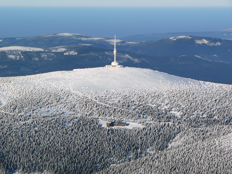 Aerial view of Praděd | |
| Highest point | |
| Elevation | 1,491 m (4,892 ft) |
| Prominence | 983 m (3,225 ft) |
| Isolation | 128 km (80 mi) |
| Coordinates | 50°5′0″N 17°14′0″E |
| Geography | |
 Praděd Location in the Czech Republic | |
| Location | Czech Republic |
| Parent range | Hrubý Jeseník |
The average annual temperature is about 1 °C (34 °F). A television transmitter is situated on the top, 162 m (531 ft) high. The upper platform is used as a watchtower. The mountain is also a popular area for skiing.
History

The first building on the mountain was a stone watchtower, 32 m (105 ft) high. It was built in 1903–1912 by the Sudeten German tourist association. After 1945, the tourist association no longer existed because all Germans were expelled. Due to its unmaintained condition in communist Czechoslovakia, with water freezing in cracks breaking it up, the watchtower collapsed 2 May 1959 shortly before it was supposed to get fixed.
The Petrovy kameny ("Peter's stones") is a gneiss stone formation near the peak. In the Middle Ages, people feared the place, believing witches lived there. The area is home to many rare plants, so it is not open to the public.[1]

The transmitter was built between 1968 and 1983. A restaurant is located in the building and can be reached by a paved road. The High Tatras, Malá Fatra Mts. and Alps can be seen from the watchtower platform.
Protection of nature
Praděd lies in the Jeseníky Protected Landscape Area. The area of the peak and its surroundings is also specially protected as the Praděd National Nature Reserve.
1950 air accident
On 27 February 1950 at 07:31 Československé státní aerolinie Douglas C-47A-15-DK on its way from Ostrava-Hrabůvka Airport to Prague Ruzyně Airport crashed into the side of Praděd mountain, killing 3 crew and 3 passengers. 25 others, including 21 passengers and 4 crew survived the accident.[2]
References
- Rocks Petrovy kameny. Accessed August 12, 2006.
- "ASN Aircraft accident Douglas C-47A-15-DK (DC-3) OK-WDY Praded Mountain".
Authority control | |
|---|---|
| General | |
| National libraries | |
На других языках
[de] Praděd
Der Praděd (deutsch Altvater) ist mit 1.491 m der höchste Berg des Altvatergebirges und gleichzeitig die höchste Erhebung von Mähren. Er gehört zum Kataster der Gemeinde Malá Morávka (Klein Mohrau) im Okres Bruntál im Mährisch-Schlesischen Kraj. Vom Gipfel bietet sich ein weiter Blick nach Mähren, Schlesien und Böhmen. Markantestes Bauwerk auf dem Altvater ist der futuristische Fernsehturm.- [en] Praděd
[es] Praděd
Praděd (en checo, Altvater en alemán, Bisabuelo en español) (1491 m) es el pico más alto de Silesia (situado en la frontera entre ambas), y quinto de la República Checa. En su cima se levanta una torre de 162 m de altura, con un restaurante y una antena repetidora de televisión, que constituye el punto artificial más elevado de la república y puede contemplarse a decenas de kilómetros a la redonda.[fr] Praděd
Praděd (littéralement « arrière grand-père », en allemand : Altvater, qui signifie « vieux père ») est une montagne de 1 491 m d'altitude, située près de Malá Morávka en Moravie, dans le nord-est de la République tchèque.[it] Praděd
Il monte Praděd (in polacco: Pradziad; in tedesco: Altvater, che significa nonno), con i suoi 1.491,3 m s.l.m. è la montagna più alta dei Hrubý Jeseník, una catena montuosa dei Sudeti Orientali.[ru] Прадед (гора)
Пра́дед (чеш. Praděd, нем. Altvater) — гора в Чехии, высочайшая вершина хребта Грубый Есеник. Является пятой по высоте горой Чехии.Другой контент может иметь иную лицензию. Перед использованием материалов сайта WikiSort.org внимательно изучите правила лицензирования конкретных элементов наполнения сайта.
WikiSort.org - проект по пересортировке и дополнению контента Википедии