geo.wikisort.org - Mountains
Piz Badile (3,308 m) is a mountain of the Bregaglia range in the Swiss canton of Graubünden and the Italian region of Lombardy. The border between the two countries runs along the summit ridge. Its north-east face, overlooking the Swiss Val Bregaglia near Soglio, is considered one of the six great north faces of the Alps.
| Piz Badile | |
|---|---|
 The north-east face and north ridge of Piz Badile | |
| Highest point | |
| Elevation | 3,308 m (10,853 ft) |
| Prominence | 262 m (860 ft)[1] |
| Parent peak | Piz Cengalo |
| Isolation | 1.1 km (0.68 mi)[2] |
| Listing | Great north faces of the Alps |
| Coordinates | 46°17′41″N 9°35′10″E |
| Geography | |
 Piz Badile Location in the Alps | |
| Location | Lombardy, Italy Graubünden, Switzerland |
| Parent range | Bregaglia Range |
| Geology | |
| Mountain type | Granite |
| Climbing | |
| First ascent | W. A. B. Coolidge with guides François Devouassoud and Henri Devouassoud on 27 July 1867 |
| Easiest route | South Ridge (Couloir Route) PD |
The first ascent of Piz Badile was by W. A. B. Coolidge with guides François Devouassoud and Henri Devouassoud on 27 July 1867 by the south ridge.[3] The mountain had first come to the notice of British alpinists from D. W. Freshfield's writings of the 1860s. He gave the name 'the Grey Twins' to Piz Badile and Piz Cengalo, and made the first ascent of Piz Cengalo in 1866.[4]
The two classic routes on Piz Badile are the north ridge and the Cassin Route on the north-east face. The north ridge – the Badilekante – was first prospected solo by the Swiss guide Christian Klucker in 1892 (Klucker later made the first ascent of the Badile's west-south-west ridge with Anton von Rydzewski and M. Barbaria on 14 June 1897). After several unsuccessful attempts by Italian parties in 1911, the ridge (IV, one pitch of V-) finally fell to Alfred Zürcher with the guide Walter Risch on 4 August 1923. F. l'Orsa and André Roch found a more direct line on the ridge on the second ascent (18 July 1926).[3]
The most popular route on the north-east face is the Cassin Route (V+/A0 or VI+), so-called after the first ascentionist Riccardo Cassin, who climbed it with V. Ratti and G. Esposito, together with the Como team of Mario Molteni and Giuseppe Valsecchi on 14–16 July 1937. Molteni and Valsecchi were already on the face when Cassin and his party started out, but the climbers subsequently joined forces. In this famous alpine epic, Molteni died of exhaustion and exposure on the summit, whilst Valsecchi died on the descent by the south ridge just before reaching the hut.[3]
The name Badile means spade or shovel (arising from the mountain's appearance when viewed from the Val Bregaglia).
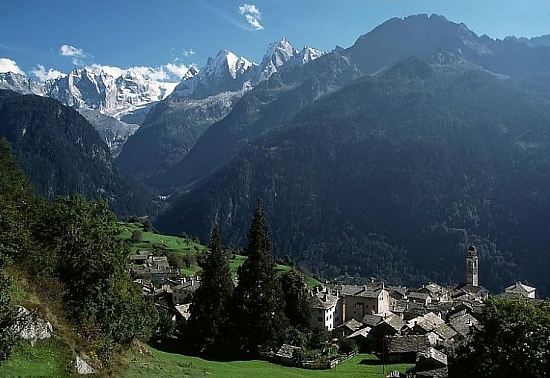
 View from above Soglio of the Sciora peaks (left), Piz Cengalo (left centre) and Piz Badile (centre)
 Piz Badile from the Val Bondasca
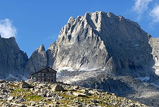 Piz Badile and the Giannetti hut from the south


Huts
- Giannetti hut (2,534 m)
- Sasc Furä hut (1,904 m)
- Sciora hut (2,118 m)
References
- Retrieved from the Swisstopo topographic maps. The key col is located east of Punta Sertori at 3,046 metres.
- Retrieved from Google Earth. The nearest point of higher elevation is west of Piz Cengalo.
- Collomb, Robin, Bregaglia West, Goring: West Col Productions, 1988
- Engel, Claire, Mountaineering in the Alps, London: George Allen and Unwin, 1971
External links
| Wikimedia Commons has media related to Piz Badile. |
- Piz Badile on SummitPost
- Piz Badile on Hikr
- An account of an ascent of the north-east face of Piz Badile in 1961
Authority control | |
|---|---|
| General |
|
| National libraries | |
На других языках
[de] Piz Badile
Der Piz Badile (italienisch: Pizzo Badile; Piz ist sowohl im rätoromanischen wie im Bergeller Dialekt („Bregagliott“) das Wort für Spitze, 'Badile' heisst im Italienischen 'Schaufel') ist ein markanter Berg der Bergeller Alpen im Süden des Kantons Graubünden in der Schweiz.- [en] Piz Badile
[es] Piz Badile
Piz Badile en alemán, Pizzo Badile en italiano es una montaña 3.308 msnm del Val Bregaglia en Suiza e Italia, la cual constituye una frontera natural entre los dos países. Es la cima más conocida de los Montes de la Val Bregaglia. Se encuentra entre el Valle Masino en la provincia de Sondrio y el Valle Bondasca al norte, un valle lateral del Valle Bregaglia.[fr] Pizzo Badile
Le pizzo Badile est un sommet des Alpes, à 3 308 mètres d'altitude, dans la chaîne de la Bernina, dans le Val Bregaglia à cheval entre l'Italie et la Suisse.[it] Pizzo Badile
Il Pizzo Badile (3.308 m s.l.m. - piz Badile in romancio) è la cima più conosciuta dei monti della val Bregaglia, al confine tra l'Italia e la Svizzera. È situato fra la val Masino in provincia di Sondrio e la val Bondasca a nord, una valle laterale della val Bregaglia. La sua parete nord rappresenta una delle classiche pareti nord delle Alpi.Другой контент может иметь иную лицензию. Перед использованием материалов сайта WikiSort.org внимательно изучите правила лицензирования конкретных элементов наполнения сайта.
WikiSort.org - проект по пересортировке и дополнению контента Википедии