geo.wikisort.org - Mountains
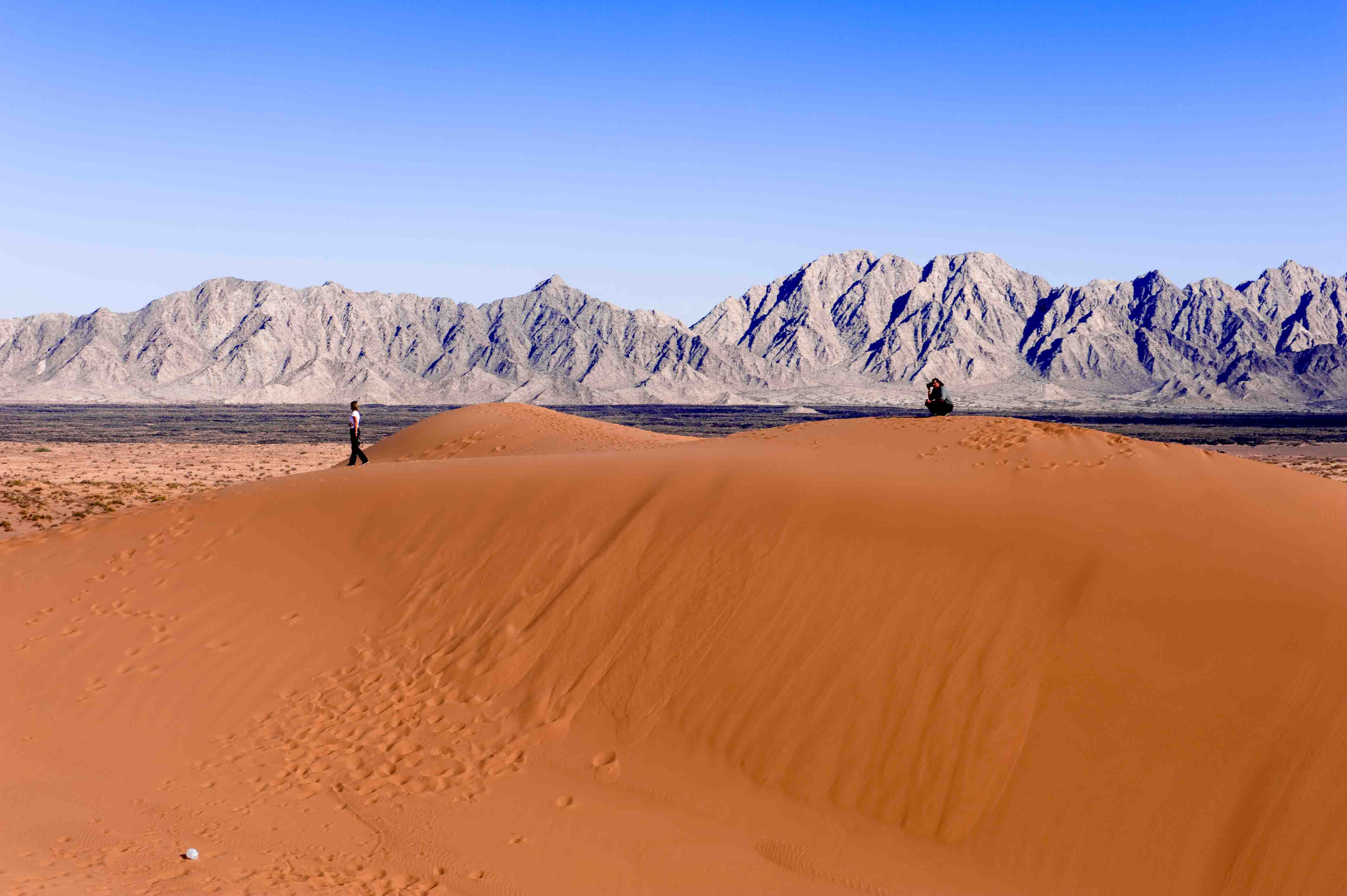
The Pinacate Peaks (Sierra Pinacate, O'odham: Cuk Doʼag) are a group of volcanic peaks and cinder cones located mostly in the Mexican state of Sonora along the international border adjacent to the U.S. state of Arizona, surrounded by the vast sand dune field of the Gran Desierto de Altar, at the desert's southeast.[1]
| Pinacate Peaks | |
|---|---|
| Cuk Doʼag Sierra del Pinacate | |
 Pinacate Peaks Location of Sierra Pinacate in Sonora  Pinacate Peaks Pinacate Peaks (Mexico) | |
| Highest point | |
| Elevation | 1,190 m (3,900 ft) |
| Coordinates | 31.77°N 113.49°W |
| Geography | |
| Location | (north-central)-Sonoran Desert El Pinacate y Gran Desierto de Altar, Sonora, Mexico |


The Spanish name for the Pinacate Peaks geographic feature is the Sierra Pinacate, which is used in their homeland of Mexico.
Location
The Pinacate Peaks lie just north of the fishing resort of Puerto Peñasco. The tallest of the peaks is Cerro del Pinacate (also called Volcan Santa Clara), elevation 3,904 feet (1,190 m). The Mexican Spanish word pinacate is derived from the Nahuatl word for the endemic desert stink beetle, pinacatl.
Natural History
Geology
The volcanoes here have erupted here sporadically since about 4 million years ago, probably in association with the opening of the Gulf of California. The most recent volcanic activity was about 11,000 years ago. The Pinacate Desert is home to the largest sand dunes of the Americas.[2]
Flora and fauna
A variety of flora and fauna occur in the Pinacate Mountains, including the sculptural Elephant Tree, Bursera microphylla.[3]
Human history
Padre Eusebio Kino, founder of many Spanish missions in the Sonoran Desert, explored here in 1698 and several times later.
NASA sent astronauts here starting in 1965 for geologic training, given the similarity of the terrain to the lunar surface, and included training models of lunar surface equipment. Apollo 14's Alan Shepard and Ed Mitchell, and Apollo 17's Jack Schmitt trained here in Feb. 1970.[4]
El Pinacate y Gran Desierto de Altar Biosphere Reserve
The El Pinacate y Gran Desierto de Altar Biosphere Reserve is a biosphere reserve, in the spanish language Reserva de la Biosfera el Pinacate y Gran Desierto de Altar, managed by the Mexican Federal Government's SEMARNAT - the Ministry of the Environment and Natural Resources, in collaboration with the government of the State of Sonora's IMADES agency.[5]
The reserve
Facts about the reserve:[6]
- Over 600 square miles (1,600 km2)
- Over 400 cinder cones (caused by volcanic activity)
- 9 massive volcanic craters
- Remains of volcanic activity (ash, basalt rock, lava fields)
- Over 560 plant species
- 56 mammal species
- 43 reptile species
- 222 bird species
- 4 fish species.
See also
References
- U.S. National Aeronautics and Space Administration. NASA Information and Satellite Image: Pinacate Mountains
- "Biological Sciences".
- C. Michael Hogan. 2009. Elephant Tree: Bursera microphylla, GlobalTwitcher.com, ed. N. Stromberg Archived 2012-03-07 at the Wayback Machine
- Phinney, William (2015). Science Training History of the Apollo Astronauts. NASA SP -2015-626. p. 236.
- "Pinacate and Gran Desierto de Altar Biosphere Reserve". Archived from the original on 2011-07-21. Retrieved 2010-10-01. . accessed 7/22/2010
- "Pinacate Biosphere Reserve, Mexico - Desert Invasion - U.S."
External links
- Official Pinacate y Gran Desierto de Altar Biosphere Reserve website
- Sierra Pinacate a Volcanic Wonder
- Global Volcanism Program: Pinacate Mountains
- Cerro Pinacate, at summitpost
| Authority control |
|
|---|
На других языках
[de] Cerro del Pinacate
Der Cerro del Pinacate ist ein Berg im mexikanischen Bundesstaat Sonora. Der Berg ist 1190 m hoch und damit die höchste Erhebung der Pinacate Peaks (auch Sierra del Pinacate). Er liegt in der Sonora-Wüste zwischen dem Golf von Kalifornien und dem US-Bundesstaat Arizona.- [en] Pinacate Peaks
[es] Sierra del Pinacate
La Sierra del Pinacate es un grupo volcánico de montañas, cráteres y conos localizados en el estado mexicano de Sonora a lo largo de la frontera internacional adyacente al estado de EE.UU. de Arizona, rodeado por un vasto campo de dunas de arena del Gran Desierto de Altar.[1][ru] Сьерра-Пинакате
Сьерра-Пинакате (исп. Sierra Pinacate) — группа вулканических пиков и шлаковых конусов, расположенных в штате Сонора (Мексика) вдоль границы с Аризоной (США). Вулканы Сьерра-Пинакате расположены на юго-востоке великой пустыни Альтар и окружены песчаными дюнами[1].Другой контент может иметь иную лицензию. Перед использованием материалов сайта WikiSort.org внимательно изучите правила лицензирования конкретных элементов наполнения сайта.
WikiSort.org - проект по пересортировке и дополнению контента Википедии