geo.wikisort.org - Mountains
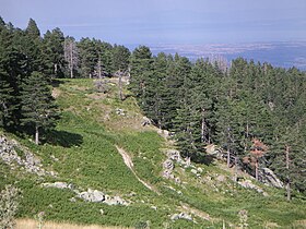
The Pierian Mountains (or commonly referred to as Piéria) are a mountain range between Imathia, Pieria and Kozani Region, south of the plain of Kambania in Central Macedonia, Greece. The village of Vergina, where the archaeological site of ancient Aigai lies, is built at the foot of these mountains. The highest point in the range is Flampouro at 2,193m (7,195 feet).The Pierian Mountains are the site of the ski resort of Elatochori.
This article does not cite any sources. (February 2011) |
| Pierian Mountains | |
|---|---|
 Sarakatsana location on the Pierian Mountains | |
| Highest point | |
| Elevation | 2,193 m (7,195 ft) |
| Coordinates | 40°14′06″N 22°10′39″E |
| Geography | |
| Location | Greece |
| Parent range | Natural border between Central Macedonia and West Macedonia |
Flora
Pierian Mountains are known for their rich flora, mainly for their deciduous forests as well as for some rare species of wild flowers. The mountains are lush with rich and diverse vegetation made of dense forests of beech, oak and chestnut, black and red pines; while shrubs and deciduous trees are found at the lowest levels.
Accidents
On 17 December 1997, a Yakovlev Yak-42 of Aerosvit Airlines, operating the route from Odessa, Ukraine to Thessaloniki, lost contact with the airport's air traffic control and during the second attempt the aircraft crashed in the Pierian mountains, near Mount Olympus. A total of 70 people, passengers and crew, 41 of which were Greeks, were killed.
Gallery
External links
- Greek Mountain Flora
- Pieria Mountains terrain map by Geopsis
На других языках
[de] Pieria-Gebirge
Die Pieria-Berge (griechisch Πιέρια Όρη, in slavischen Sprachen Schapka Planina, Шапка) sind ein Gebirgsmassiv nordwestlich des Olymps. Sie erstrecken sich über die Regionalbezirke Imathia, Pieria und Kozani.- [en] Pierian Mountains
[fr] Monts de Piérie
Les monts de Piérie (en grec moderne : Πιέρια όρη, ou communément appelées Piéria) sont un massif de montagnes entre les districts régionaux d'Imathie, de Piérie et de Kozani, au sud de la plaine de Kambanía en Macédoine-Centrale, en Grèce.[it] Monti della Pieria
Il Monti della Pieria o Monti Pieri (greco: Πιέρια Όρη) sono una catena montuosa della Macedonia Centrale nel nord della Grecia. È una montagna alta 1.201 m. della Macedonia Centrale nel nord-est della Grecia. Sono poste al confine fra le prefetture di Emazia, Pieria e Kozani. La cima più alta della catena è il monte Flampouro a 2.193 m.[ru] Пиерия (горы)
Пие́рия[1] (греч. Πιέρια) — горы в Греции. Расположены к северу от Олимпа и Камвунии, в периферийных единицах Иматии и Пиерии в периферии Центральной Македонии и в периферийной единице Козани в периферии Западной Македонии. Западнее течёт Альякмон и находятся горы Вермион. Самый высокий пик — Фламбуро (Φλάμπουρο) высотой 2190 метров[1], в древности известный как Пиерий (др.-греч. Πιέριον ή Πίερος)[2]. Горы покрыты сосновым лесом и имеют множество источников, впадающих в Альякмон и залив Термаикос. Пиерия и Олимп образуют теснину Петры (греч.) (рус., через которую проходит национальная дорога 13 (греч.) (рус. Эласон — Катерини.Другой контент может иметь иную лицензию. Перед использованием материалов сайта WikiSort.org внимательно изучите правила лицензирования конкретных элементов наполнения сайта.
WikiSort.org - проект по пересортировке и дополнению контента Википедии

