geo.wikisort.org - Mountains
Picture Peak is a 13140+ foot (4001+ m) mountain summit located one mile east of the crest of the Sierra Nevada mountain range in Inyo County in northern California, United States. It is situated in the John Muir Wilderness, on land managed by Inyo National Forest. It is approximately 21 miles (34 km) west of the community of Big Pine, and 0.65 miles (1.05 km) east of parent Mount Haeckel. Topographic relief is significant as the north aspect rises over 2,000 feet (610 meters) above Hungry Packer Lake in approximately one-half mile (1 km). The first ascent of the summit was made July 1967, by Gary Colliver and Steve Thompson via the northeast face.[4] This mountain's name has not been officially adopted by the U.S. Board on Geographic Names.
| Picture Peak | |
|---|---|
 North aspect | |
| Highest point | |
| Elevation | 13140+ ft (4001+ m)[1] |
| Prominence | 240 ft (73 m)[1] |
| Parent peak | Mount Haeckel[2] |
| Isolation | 0.51 mi (0.82 km)[1] |
| Coordinates | 37°09′03″N 118°38′57″W[1] |
| Geography | |
 Picture Peak  Picture Peak | |
| Location |
|
| Parent range | Sierra Nevada |
| Topo map | USGS Mount Darwin |
| Geology | |
| Type of rock | Granitic |
| Climbing | |
| First ascent | 1931 by Norman Clyde[3] |
| Easiest route | Exposed scramble, class 3[3] |
Climate
According to the Köppen climate classification system, Picture Peak is located in an alpine climate zone.[5] Most weather fronts originate in the Pacific Ocean, and travel east toward the Sierra Nevada mountains. As fronts approach, they are forced upward by the peaks, causing them to drop their moisture in the form of rain or snowfall onto the range (orographic lift). Precipitation runoff from this mountain drains into headwaters of the South Fork Bishop Creek.[citation needed]
Climbing
Established climbing routes on Picture Peak:[6]
- Southwest Gully – class 3
- Northeast Face – class 5.9
- Northeast Buttress – class 5.10b
Gallery
 Picture Peak centered, north aspect, from Sabrina Lake area
(Clyde Spires to left, the top of Mt. Wallace visible to right)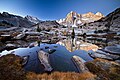 Picture Peak centered, from Sailor Lake.
Mt. Haeckel in upper right corner in back. Picture Peak from Hungry Packer Lake
 Picture Peak from Bishop Creek Valley
 Picture Peak (left) and Mt. Haeckel (right) from Bishop Creek Valley


See Also
 Mountains portal
References
- "Picture Peak, California". Peakbagger.com. Retrieved 2021-04-24.
- "Picture Peak". ListsOfJohn.com. Retrieved 2021-12-02.
- Secor, R.J. (1992). The High Sierra Peaks, Passes, and Trails (1st ed.). Seattle: The Mountaineers. pp. 226–227. ISBN 978-0898863130.
- John Moynier, Claude Fiddler, 1993, Sierra Classics: 100 Best Climbs in the High Sierra, Chockstone Press, ISBN 9780934641609, page 158.
- Peel, M. C.; Finlayson, B. L.; McMahon, T. A. (2007). "Updated world map of the Köppen−Geiger climate classification". Hydrol. Earth Syst. Sci. 11. ISSN 1027-5606.
- Picture Peak, Mountainproject.com
External links
- Picture Peak Rock Climbing: Mountainproject.com
Другой контент может иметь иную лицензию. Перед использованием материалов сайта WikiSort.org внимательно изучите правила лицензирования конкретных элементов наполнения сайта.
WikiSort.org - проект по пересортировке и дополнению контента Википедии