geo.wikisort.org - Mountains
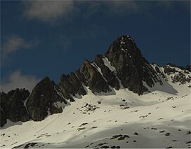
Pic Ramougn (3,011 m) is a steep, rocky mountain in the Néouvielle massif in the Pyrenees.
| Pic Ramougn | |
|---|---|
 North side of Pic Ramougn from Hourquette d'Aubert | |
| Highest point | |
| Elevation | 3,011 m (9,879 ft) |
| Prominence | 60 m (200 ft) |
| Coordinates | 42°50′06″N 00°07′12″E |
| Geography | |
 Pic Ramougn Location in the Pyrenees | |
| Location | Hautes-Pyrénées, France |
| Parent range | Pyrenees |
| Geology | |
| Mountain type | Granite |
It is located in the commune of Saint-Lary-Soulan within the department of the Hautes-Pyrénées, and is named after the French politician, geologist and botanist Louis Ramond de Carbonnières. Ramougn is the pronunciation of Ramond in the Gascon language.
External links
На других языках
- [en] Pic Ramougn
[fr] Pic Ramougn
Le pic Ramougn, ou pic Ramoun, est un sommet des Pyrénées françaises dans le massif du Néouvielle, département des Hautes-Pyrénées, région Occitanie.Текст в блоке "Читать" взят с сайта "Википедия" и доступен по лицензии Creative Commons Attribution-ShareAlike; в отдельных случаях могут действовать дополнительные условия.
Другой контент может иметь иную лицензию. Перед использованием материалов сайта WikiSort.org внимательно изучите правила лицензирования конкретных элементов наполнения сайта.
Другой контент может иметь иную лицензию. Перед использованием материалов сайта WikiSort.org внимательно изучите правила лицензирования конкретных элементов наполнения сайта.
2019-2025
WikiSort.org - проект по пересортировке и дополнению контента Википедии
WikiSort.org - проект по пересортировке и дополнению контента Википедии