geo.wikisort.org - Mountains
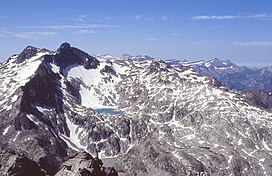
Pic Long (3,192 m) is the highest mountain in the Néouvielle massif in the Pyrenees.
| Pic Long | |
|---|---|
 Pic Long's North face overlooks Tourrat Lake (view from Turon de Néouvielle) | |
| Highest point | |
| Elevation | 3,192 m (10,472 ft) |
| Prominence | 726 m (2,382 ft) |
| Coordinates | 42°48′04″N 0°06′01″E |
| Geography | |
 Pic Long Location in the Pyrenees | |
| Location | Hautes-Pyrénées, France |
| Parent range | Pyrenees |
| Climbing | |
| First ascent | 13 August 1890 by Henri Brulle, Célestin Passet and François Brenat-Salles |
It is located in the commune of Saint-Lary-Soulan within the department of the Hautes-Pyrénées.
External links
На других языках
- [en] Pic Long
[fr] Pic Long
Le pic Long est un sommet des Pyrénées françaises. Avec ses 3 192 mètres, c'est le plus haut sommet du massif du Néouvielle et le troisième plus haut sommet des Pyrénées situé entièrement en France, après la pointe Chausenque et le piton Carré.Текст в блоке "Читать" взят с сайта "Википедия" и доступен по лицензии Creative Commons Attribution-ShareAlike; в отдельных случаях могут действовать дополнительные условия.
Другой контент может иметь иную лицензию. Перед использованием материалов сайта WikiSort.org внимательно изучите правила лицензирования конкретных элементов наполнения сайта.
Другой контент может иметь иную лицензию. Перед использованием материалов сайта WikiSort.org внимательно изучите правила лицензирования конкретных элементов наполнения сайта.
2019-2025
WikiSort.org - проект по пересортировке и дополнению контента Википедии
WikiSort.org - проект по пересортировке и дополнению контента Википедии