geo.wikisort.org - Mountains
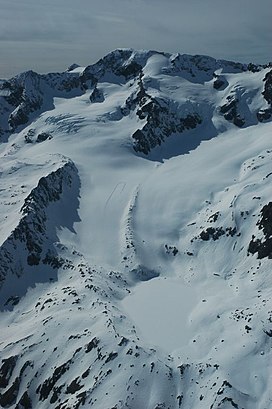
Pic Bayle is a summit in the Dauphiné Alps, culminating at a height of 3,465 m (11,368 ft), the highest point of the Massif des Grandes Rousses. It is above the resort of Alpe D'Huez.
| Pic Bayle | |
|---|---|
 Pic Bayle | |
| Highest point | |
| Elevation | 3,465 m (11,368 ft) |
| Prominence | 1,175 m (3,855 ft)[1] |
| Listing | Alpine mountains above 3000 m |
| Coordinates | 45°08′17″N 6°08′09″E[2] |
| Geography | |
 Pic Bayle Rhône-Alpes, France | |
| Parent range | Dauphiné Alps |
| Climbing | |
| First ascent | 1874 by Joseph Bayle |
References
- "Pic Bayle". Peakbagger.com. Retrieved 16 January 2015.
- Source : Géoportail avec carte IGN à l'échelle 1:25000
На других языках
- [en] Pic Bayle
[fr] Pic Bayle
Le pic Bayle est le point culminant du massif des Grandes Rousses, dans le département de l'Isère.[it] Pic Bayle
Il Pic Bayle (3.465 m s.l.m.) è la montagna più alta della Catena Grandes Rousses nelle Alpi del Delfinato. Si trova nel dipartimento francese dell'Isère.Текст в блоке "Читать" взят с сайта "Википедия" и доступен по лицензии Creative Commons Attribution-ShareAlike; в отдельных случаях могут действовать дополнительные условия.
Другой контент может иметь иную лицензию. Перед использованием материалов сайта WikiSort.org внимательно изучите правила лицензирования конкретных элементов наполнения сайта.
Другой контент может иметь иную лицензию. Перед использованием материалов сайта WikiSort.org внимательно изучите правила лицензирования конкретных элементов наполнения сайта.
2019-2025
WikiSort.org - проект по пересортировке и дополнению контента Википедии
WikiSort.org - проект по пересортировке и дополнению контента Википедии