geo.wikisort.org - Mountains
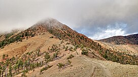
Pearsoll Peak is a mountain in the Klamath Mountains of southwestern Oregon in the United States. It is located in the northern Kalmiopsis Wilderness in southeastern Curry County and western Josephine County in the extreme southwest corner of the state, approximately 20 miles (32 km) from the Pacific Ocean and 20 miles (32 km) north of the California state line. It has a fire lookout on top that was spared in the Biscuit Fire of 2002.
| Pearsoll Peak | |
|---|---|
 | |
| Highest point | |
| Elevation | 5,098 ft (1,554 m) NAVD 88[1] |
| Prominence | 2,600 ft (792 m)[2] |
| Coordinates | 42°17′55″N 123°50′47″W[1] |
| Geography | |
 Pearsoll Peak Location in Oregon | |
| Location | Curry / Josephine counties, Oregon, U.S. |
| Parent range | Klamath Mountains |
| Topo map | USGS Pearsoll Peak |
| Climbing | |
| Easiest route | high clearance vehicle or hike[3] |
References
- "Pearsoll". NGS data sheet. U.S. National Geodetic Survey. Retrieved 2008-04-01.
- "Pearsoll Peak, Oregon". Peakbagger.com. Retrieved 2008-04-01.
- "Pearsoll Peak (OR)". SummitPost.org. Retrieved 2016-04-29.
External links
- "Pearsoll Peak". Geographic Names Information System. United States Geological Survey.
- "Picture gallery". Flickr.
Текст в блоке "Читать" взят с сайта "Википедия" и доступен по лицензии Creative Commons Attribution-ShareAlike; в отдельных случаях могут действовать дополнительные условия.
Другой контент может иметь иную лицензию. Перед использованием материалов сайта WikiSort.org внимательно изучите правила лицензирования конкретных элементов наполнения сайта.
Другой контент может иметь иную лицензию. Перед использованием материалов сайта WikiSort.org внимательно изучите правила лицензирования конкретных элементов наполнения сайта.
2019-2025
WikiSort.org - проект по пересортировке и дополнению контента Википедии
WikiSort.org - проект по пересортировке и дополнению контента Википедии