geo.wikisort.org - Mountains
Padres Butte is a butte near the tip of Padre Point on the south shore of Lake Powell in San Juan County, Utah, United States.
| Padres Butte | |
|---|---|
 East aspect of Padres Butte, June 2015 | |
| Highest point | |
| Elevation | 4,043 ft (1,232 m)<=[1] |
| Prominence | 463 ft (141 m)[1] |
| Parent peak | Dominguez Butte[1] |
| Isolation | 1.29 mi (2.08 km)[1] |
| Coordinates | 37°02′54″N 111°16′58″W[2] |
| Geography | |
 Padres Butte Location in Utah  Padres Butte Padres Butte (the United States) | |
| Location | Glen Canyon National Recreation Area San Juan County, Utah, U.S. |
| Parent range | Colorado Plateau |
| Topo map | USGS Gunsight Butte |
| Geology | |
| Age of rock | Jurassic |
| Type of rock | Entrada Sandstone |
| Climbing | |
| Easiest route | class 5.x climbing[1] |
Description
The summit of the butte has an elevation of 4,043 feet (1,232 m). It was formerly an island in the man-made lake, but land connecting the butte with the rest of Padre Point has been exposed as the lake's water levels have declined.[3][4]
Padres Butte marks the site of the historical Crossing of the Fathers, a series of sand bars along the great bend in the Colorado River a mile west of the butte that once offered a fordable crossing of the river.[5] This geographical feature's name was officially adopted in 1961 by the U.S. Board on Geographic Names.[2]
According to the Köppen climate classification system, Gregory Butte is located in an arid climate zone with hot, very dry summers, and chilly winters with very little snow.[6]
Gallery
 Southeast aspect
 Northeast aspect
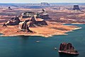 Padres Butte in lower right corner


See also
- Colorado Plateau
References
- "Padres Butte – 4,043' UT". listsofjohn.com. Retrieved 2020-11-11.
- "Padres Butte". Geographic Names Information System. United States Geological Survey. Retrieved 2020-11-11.
- U.S. Geological Survey Geographic Names Information System: Padres Butte
- U.S. Geological Survey Geographic Names Information System: Padre Point
- U.S. Geological Survey Geographic Names Information System: Crossing of the Fathers (historical)
- Peel, M. C.; Finlayson, B. L.; McMahon, T. A. (2007). "Updated world map of the Köppen−Geiger climate classification". Hydrol. Earth Syst. Sci. 11. ISSN 1027-5606.
External links
| Wikimedia Commons has media related to Padres Butte. |
- Weather forecast: Padres Butte
Другой контент может иметь иную лицензию. Перед использованием материалов сайта WikiSort.org внимательно изучите правила лицензирования конкретных элементов наполнения сайта.
WikiSort.org - проект по пересортировке и дополнению контента Википедии