geo.wikisort.org - Mountains
Otse Hill is a peak often cited as the highest point of Botswana, with a reported altitude of 1,491 metres (4,891 feet). It is located in the village of Otse, South-East District. Its highest cell on SRTM data is 1,486 meters - 4875 feet. The 1999 Department of Surveys and Mapping (Gaborone) 1:50,000 scale topographic map shows a "trigonometrical station" on the Otse Peak summit with an elevation of 1,491 meters - 4892 feet.
| Otse Hill | |
|---|---|
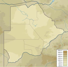 Otse Hill Location in Botswana | |
| Highest point | |
| Elevation | 1,491 m (4,892 ft) 1:50,000 scale Botswana government topographic map, trig station |
| Listing | Country high point |
| Coordinates | 25°00′30″S 25°42′57″E |
| Geography | |
| Location | Otse, South-East District, Botswana |
The Monalanong Hill (at a SRTM-derived altitude of 1,494 metres - 4,902 feet) or the Tsodilo Hills (at an altitude of about 1400 metres - 4,593 feet) are also often given as the highest point in Botswana.[1]
Notes
- (in English) Territorial Highest points Archived 2009-03-23 at the Wayback Machine, World Heritage Site, accessed on April 10, 2009.
See also
- Geography of Botswana
This Botswana location article is a stub. You can help Wikipedia by expanding it. |
На других языках
- [en] Otse Hill
[fr] Otse Hill
Otse Hill est une montagne du Botswana, le point culminant du pays. Il se situe à une altitude de 1 491 mètres dans le district du Sud-Est près d'Otse.Текст в блоке "Читать" взят с сайта "Википедия" и доступен по лицензии Creative Commons Attribution-ShareAlike; в отдельных случаях могут действовать дополнительные условия.
Другой контент может иметь иную лицензию. Перед использованием материалов сайта WikiSort.org внимательно изучите правила лицензирования конкретных элементов наполнения сайта.
Другой контент может иметь иную лицензию. Перед использованием материалов сайта WikiSort.org внимательно изучите правила лицензирования конкретных элементов наполнения сайта.
2019-2026
WikiSort.org - проект по пересортировке и дополнению контента Википедии
WikiSort.org - проект по пересортировке и дополнению контента Википедии